Solar and lunar associations
Planetary and stellar associations
Cautionary remarks
Theme: Later prehistoric Europe
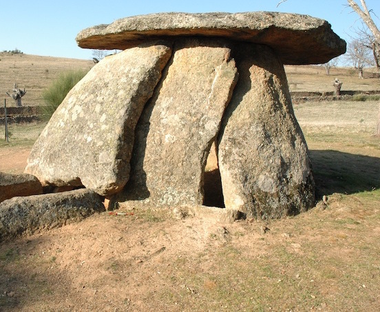
The later prehistoric period within Europe, and particularly around the Atlantic façade, marks the widespread construction of large, evidently communal, structures built predominantly of earth, timber and/or stone. The vestiges of many earthworks and stone monuments dating to this period remain conspicuous in today’s landscape. People have long identified tangible connections with the sky at such monuments, mostly in the form of alignments upon the rising and setting points of particular celestial objects, such as the sun at the summer or winter solstice. Such alignments remain the focus of much attention among both professional archaeoastronomers and enthusiastic amateurs.
In dealing with such alignments one must take account of three fundamental issues. First, every oriented structure must point somewhere, whether intentionally or not. Second, several different factors might have influenced a structural orientation, of which only a few are related to the sky. Third, there are many potential astronomical targets, some of which may have shifted significantly within the chronological timeframe that can be identified from the broader archaeological evidence. There is, therefore, a strong likelihood of being able to fit a fortuitous astronomical alignment to almost any structural orientation, which is increased still further if one is prepared to choose the ‘best fit’ date.
One way to establish the intentionality of an alignment and to sustain a plausible astronomical explanation is to identify repeated trends. Fortunately, among European later prehistoric monuments there exist several geographically and chronologically well-defined clusters of architecturally similar constructions where systematic analyses can be, and have been, undertaken. A prerequisite is that the type of monument in question should have a clearly identifiable ‘principal axis’ or other major structural orientation whose importance can be convincingly argued on a priori grounds.
Even where an astronomical connection can be reliably established through its repetition among a group of monuments, one still needs to consider the broader archaeological context in order to interpret its cultural significance: why it was constructed, how it functioned and what social purposes it may have served. It is clear, for example, that burial tombs, even if astronomically oriented, were not ‘observatories’ if that is taken to mean that they were constructed primarily to facilitate astronomical observations. Instead, we should view the astronomical connection encapsulated in the monument as a tangible reflection of a connection existing in people’s minds between ancestors and/or ancestral spirits and the astronomical body in question. Its significance to us rests largely in revealing that connection. Similarly, astronomical alignments encapsulated in other types of monument such as enclosures and free-standing ‘temples’, even if periodically confirmed by observation, should be seen as secondary, albeit important and perhaps vital, aspects of the symbolism of those structures, whose interpretation inevitably leads to the consideration of issues such as ideology and cosmology.
Despite their continued predominance in discussions on the topic, tangible manifestations of astronomy in later prehistoric Europe are not confined to monumental alignments upon the horizon rising and setting points of celestial bodies. Other aspects of spatial patterning in the material record, as well as consideration of the situation of monuments within the landscape and human movement and experience in relation to the monuments, have become increasingly important in recent years.
Geographical and chronological context
In Europe, the term ‘later prehistory’ broadly refers to the period from the first appearance of farming communities (i.e. those who practised cultivation and/or animal husbandry) and lasted until the emergence of the classical civilizations and the Roman Empire. This covers the periods conventionally referred to as the Neolithic, Copper Age/Chalcolithic/Eneolithic, Bronze Age and Iron Age. The chronology varies from region to region: it stretches back as far as the 7th millennium BC in south-east Europe, as shown by the existence of numerous ‘tells’—mounds containing the remains of fixed settlements lasting for many generations—and lasts into the early centuries AD in places like Ireland and northern Europe where there was no Roman conquest.
The monuments that survive to characterise this period so prominently in today’s landscape include
- burial structures, typically stone chambers and passages covered, or once covered, in large earthen mounds;
- round enclosures or constructions, such as ‘henges’ and other circular earthworks, and stone circles;
- linear constructions, such as the earthen ‘cursus monuments’ concentrated in southern England, and the huge stone rows at Carnac in Brittany, France.
The main concentrations of these are around the Atlantic seaboard of western Europe, but they are also found in parts of central Europe, the Caucasus and the Russian steppes. Some, such as chambered tombs, were clearly places for the dead but may also have served a variety of functions for the living. The various purposes of others such as earthen enclosures, linear earthworks, stone circles and stone rows are much debated but they remain widely characterised as ‘ceremonial’ and/or ‘ritual’ monuments*.
Excavations have shown that many such monuments were altered and remodelled over time, Stonehenge (United Kingdom) being a famous example; another is the gradual ‘closure’ of various Scottish stone circles and their re-use as focal points for later burials. In other cases, constructions were destroyed and their component materials used for building new monuments. This is evident, for example, in Brittany (France), in the reuse of two adjacent pieces of a large menhir, presumably once standing, as the capstones in two large tombs (La Table des Marchand and Gavrinis) some 4 km apart.
* A variety of local terms is used to refer to such monuments: for example, single-chamber megalithic tombs with large capstones are known variously as dolmens, quoits, cromlechs, antas, and Hunebedden; earthen mounds as barrows, tumuli, and kurgans; and standing stones themselves as megaliths, menhirs, and orthostats.
Regional groupings of monuments
Fortunately, there exist many regional groupings of relatively modest monuments with evident similarities in construction technique and design, and presumably purpose, that can be shown, or can reasonably be assumed, to have been constructed within a relatively short period of time. The common characteristics of such monuments often include aspects of their landscape situation. Many types of monument also manifest a clear directionality, such as (in an enclosed structure such as a tomb) the direction faced by the entrance or (in the case of a standing monument) an axis of symmetry running through a distinctive feature such as the ‘recumbent’ stone (a stone set on its side rather than upright) found in certain Scottish and Irish stone circles. These principal directions are typically confined to an arc of about 120° (i.e. one third of all possible directions) or less, demonstrating beyond doubt that orientation was a factor of considerable importance to the builders. The range of directions concerned—the orientation ‘signature’, varies from group to group, along with other aspects of monument design.
Many different factors can influence a structural orientation, including constraints of the local topography (e.g., the earthen long barrows of Cranborne Chase in Dorset, southern England, whose predominantly south-easterly orientation apparently results from the long axes being preferentially oriented along natural ridges), terrestrial ‘targets’ such as other tombs (as is quite common among Neolithic passage tombs in Ireland), or prominent landscape features; even, simply, the direction of the prevailing wind. However, in most cases— given a scatter of monuments over an area with significant topographic variability—such consistency could only have been achieved by reference to the north-south line defined by the diurnal motion of the heavens. This provides the most crude, but also the most fundamental, evidence for an astronomical connection among a wide range of later prehistoric monuments in Europe.
Systematic surveys of over 3000 tombs and ‘temples’ in western Europe, from France to the Mediterranean, provide the first refinement of this evidence. Virtually no monuments face the northerly quadrant, where heavenly bodies such as the sun, moon and planets are never seen. The remaining directions can be split into four arcs: the solar rising (SR) arc to the east, corresponding to the part of the horizon where the sun rises at some time in the year; the ‘sun climbing’ (SC) arc to the SSE, corresponding to those directions where the sun is seen to climb in the sky as it passes across; the ‘sun descending’ (SD) arc to the SSW, and the sun setting (SS) arc to the west. The orientation signatures of local monument groups typically correspond to two of these arcs, namely SR/SC, SC/SD, or SD/SS. This supports the idea that the principal association was with the sun, although such conclusions are critically dependent upon the outlying orientations in the sample. Others argue for a lunar association, but this is more difficult to prove owing to the greater complexity of the lunar motions. The seven-stone antas of central Portugal and central-western Spain are of particular importance in that their orientations lie exclusively in the SR range.
A number of groups of British and Irish monuments have been studied more closely. While many of these have orientation signatures broadly similar to those just mentioned, these studies have revealed more subtle differences. In particular, certain groups of monuments at more northerly latitudes, such as the ‘recumbent stone circles’ of the Grampian region of eastern Scotland, have a clear relationship with the moon. This is thought to relate to the fact that, at these latitudes, the moon on occasion passes low across the southern sky, at which times it is especially prominent. The orientation of the site (and especially, the positioning of the recumbent stone) apparently related to observations of the full moon, and particularly its setting position, at midsummer. In other cases, such as the ‘axial stone circles’ of Counties Cork and Kerry in south-western Ireland, there is a clear orientation trend but no obvious association with any particular astronomical body.
Some of the most important groups of monuments with clear orientation trends are listed in Table 1.
Table 1. Some examples of groups of standing monuments whose principal orientations demonstrate an astronomical connection. In the lists of orientations and azimuths, outliers are excluded where they form less than 2% of the total. Key to references: R = Ruggles (1999); B = Burl (2000); H = Hoskin (2001); G = César González-García and Lourdes Costa-Ferrer, ’Orientations of the Dutch Hunebedden‘, Journal for the History of Astronomy 34 (2003), 219-226. * = The azimuths quoted are those of the chamber, which is different from that of the passage.
| Type | Date (M BC) | Location | Country | No. of sites | Orientations | Azimuths (°) | Astronomy | Ref |
|---|---|---|---|---|---|---|---|---|
| Short stone rows | 3rd/2nd? | Co. Cork, Co. Kerry | Ireland | 92 | SSW/NNE-WSW/ENE | 200/20-250/70 | Moon? | R |
| Short stone rows | 3rd/2nd? | Western Scotland | UK | 44 | SE/NW- SW/NE | 120/300-230/50 | Moon | R |
| Clava Cairns | Early 2nd | Invernessshire | UK | 28 | S-SW | 170-230 | Moon | R |
| Recumbent stone circles | Late 3rd | Grampian region | UK | 97 | SSE-SW | 150-235 | Moon | B,R |
| Earthen long barrows | 4th | Salisbury Plain | UK | 65 | NE-S | c. 50-180 | Sun (SR/SC) | R |
| Hunebedden | 4th/early 3rd | Drenthe, Groningen | Netherlands | 76 | NE-S* | 50-170* | Sun (SR/SC) | G |
| Bas-Rhône-type dolmens | 3rd | Provence, W Languedoc | France | 110 | S-NW | 170-300 | Sun (SD/SS) | H |
| Languedoc-type dolmens | 3rd | East Languedoc | France | 103 | SSE-NW | 160-300 | Sun (SD/SS) | H |
| All tombs | 4th/3rd | Iberia + W & cent. France | Portugal, Spain, France | 1576 | NE-S | 40-190 | Sun (SR/SC) | H |
| All tombs | 4th/3rd | Iberia + Pyrenees | Portugal, Spain, France | 935 | NE-S | 60-190 | Sun (SR/SC) | H |
| All tombs | 4th/3rd | West Iberia | Portugal, Spain | 324 | ENE-ESE | 60-140 | Sun (SR) | H |
| Seven-stone antas | 4th - late 3rd | Alentejo; Extremadura | Portugal, Spain | 177 | ENE-ESE | 60-130 | Sun (SR) | H |
| Taula sanctuaries | Late 2nd - early 1st | Menorca | Spain | 25 | ESE -SSW | 110- 210 | S Cross & Centaurus | H |
| Tombe di giganti | 3rd | Northern Sardinia | Italy | 158 | NE-S | 50-190 | Sun (SR/SC) | H |
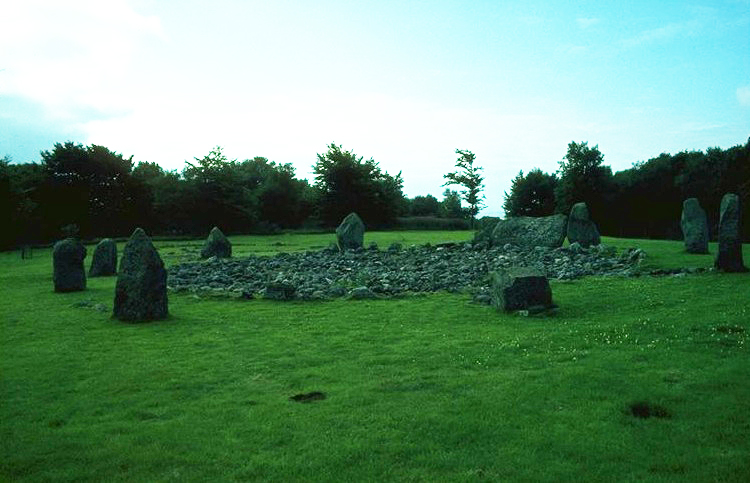
Fig. 1a. Loanhead of Daviot, Aberdeenshire, United Kingdom: one of 97 Scottish recumbent stone circles. Photograph © Clive Ruggles
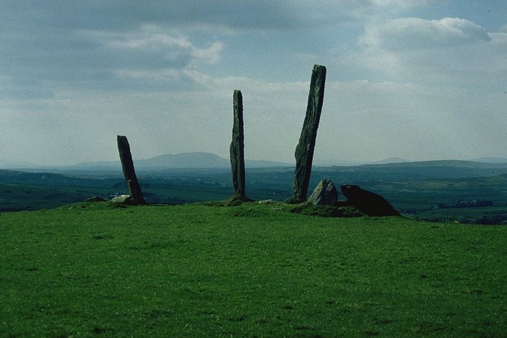
Fig. 1b. Gurranes, one of 92 short stone rows in south-west Ireland. Photograph © Clive Ruggles
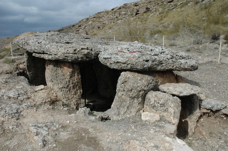
Fig. 1c. One of c. 200 oriented tombs at Río Gor, Granada, Spain. Photograph © Clive Ruggles
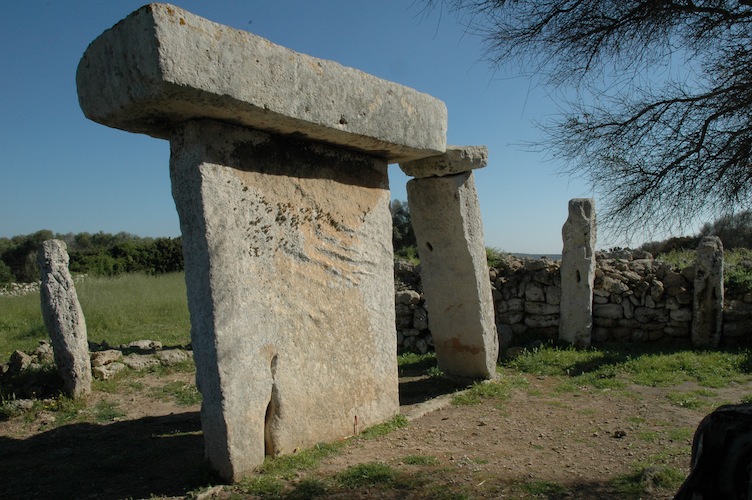
Fig. 1d. Talatí de Dalt, one of 25 taula sanctuaries in Menorca, Spain. Photograph © Clive Ruggles
Alignments in context
Countless astronomical interpretations have been put forward of individual prehistoric monuments all over Europe, and an overview will not be attempted here. If there is no statistical backing one has to provide evidence from the broader archaeological context that supports the argument that a given alignment or other astronomical association was in fact intentional. The advantage of this ‘contextual’ approach over a purely statistical one is that it can also address the question of the meaning(s) and significance of the associations to the people who created and used them, making use of theoretical approaches and interpretative tools developed within archaeology as a whole.
At Stonehenge (United Kingdom), for example, not only is the intentionality of the solstitial alignment confirmed by the fact that it is shared by a number of contemporary monuments in the vicinity, but archaeological evidence concerning the timing of feasts, and landscape features such as a solstitially aligned avenue at nearby Durrington Walls, provide plausible interpretations in terms of seasonal processions and rituals. More interestingly still, the recent discovery that the Stonehenge avenue seems to overlie natural geological striationsin the landscape, which are themselves solstitially aligned, suggests that what seems to us an accident of nature may, for Neolithic people, have provided the ultimate cosmological confirmation of the special nature of this place and be the reason that Stonehenge was eventually built here.
Things are not so clear in the Boyne valley (Ireland), where the famous midwinter sunset alignment of Newgrange passage tomb is not repeated at the nearby large passage tombs of Knowth and Dowth, although their passages (two in each case) are all aligned within the solar rising and setting ranges. ‘Satellite’ tombs surrounding Knowth, oriented inwards towards the larger tomb, remind us that as far as determining orientation was concerned, astronomy was just one possible factor among many.
In the case of the Clava cairns, a small group of Bronze-Age monuments around Inverness, Scotland, the two approaches are in conflict: a ‘statistical’ study of the orientations of the group as a whole suggests that they are associated with the setting position of the midsummer full moon, whereas an archaeological excavation of the largest site, Balnuaran of Clava—where two tombs are aligned very closely on the setting midwinter sun (which is in the middle of the lunar range)—has uncovered evidence that the architectural construction was compromised in order to incorporate the precise solstitial alignment. In other words, in this one case the solar alignment was clearly deliberate, yet it is not repeated at the other sites. This paradox can only resolved by surmising that a particular (solar) practice was developed at this ‘special’ site in the midst of a more general local (lunar) tradition.
In a few cases, the alignment evidence deserves particular attention despite the lack of any wider corroboration. A good example is a rectangular setting of standing stones at Crucuno, Brittany (France)—something that is highly unusual in itself—whose sides are aligned in the cardinal directions but whose diagonals are aligned solstitially. In other cases, wider arguments are brought to bear. For example, the solstitial alignment of the ‘large sanctuary’ at the Dacian fortress at Sarmizegetusa Regia, Romania (1st century AD), is ‘theoretical’ rather than efficacious in that it pays no attention to the altitude of the horizon in the sunrise direction; however, the existence of what is thought to be a sundial and apparent calendrical symbolism in the numbers and patterns of the kerbstones, together with the possibility of contact with Hellenistic Greece, renders it more likely that the sacred centre did have a geometrical and astronomical significance.
Alignments in context
All of the astronomical alignments discussed so far are thought to be related to the sun or moon. Alignments upon the rising and setting positions of the planets, if they existed, are unlikely to be distinguishable from the archaeological evidence alone. This is because the ‘extreme’ rising and setting positions of the planets are complex, giving rise to many equally plausible ‘targets’; and in any case all the possible positions are close to those of the sun and moon, since the planets’ motions are confined to a region close to the ecliptic plane, and not easily distinguishable from them.
It is generally difficult to prove the intentionality of stellar alignments on the basis of archaeological evidence alone. This is because of the large number of stars and the fact that their rising and setting positions shift significantly on a timescale of centuries owing to the precession of the equinoxes. This means that it is all too easy to fit a putative stellar alignment by positing a date that falls within the chronological range suggested by the other archaeological evidence. Speculations about alignments upon the rising and setting positions of stars are further complicated by complex and often unpredictably variable effects such as atmospheric refraction and extinction.
Nonetheless, plausible contextual arguments for a stellar association have been made in a few cases. One is the pre-talayotic sanctuary of Son Mas in Mallorca, Spain, from which the stars of the Southern Cross and ‘Pointers’ (α and β Centauri) would have made a brief but spectacular appearance in a prominent valley to the south up until about 1700 BC, the date at which archaeological evidence suggests the site was abandoned. One interpretation is that the abandonment—for which the archaeological evidence suggests no other reason—took place because the critical stars disappeared. Another example is the Thornborough henges (3rd millennium BC) in Yorkshire, UK, which archaeological evidence suggests was an important pilgrimage centre; the alignment evidence backs the idea that the appearance of certain asterisms (the stars of Orion’s Belt) provided the ‘trigger’ for people to set out from considerable distances in order to arrive at the appropriate time for the autumn festival.
Alignments in context
It remains necessary to caution against unsupportable interpretations, typically based upon astronomical ‘alignment hunting’ without regard either for statistical underpinning or, most crucially, for the archaeological context. Stonehenge itself, although recognised throughout the world as an icon of ancient astronomy, epitomises such problems. Its continuing public perception as some sort of ‘ancient observatory’ owes much to arguments for multiple solar and lunar alignments made in the 1960s, ideas which are thoroughly undermined by the archaeological evidence as well as statistically unsupportable. Modern political and nationalist agendas can sometimes overemphasize the importance of putative alignments at ancient sites (ironically, sometimes publicised as local ‘Stonehenges’) in support of interpretations that emphasize ancient ‘achievements’; this is misguided because the achievements concerned are conceived and measured in modern terms. The most notorious example is the use of the Odry site in northern Poland for propaganda purposes by the Nazis in the 1930s.
Alignments upon horizon rising and setting positions of astronomical objects have dominated the discussion of astronomy in later European prehistory for many decades. To some extent this is inevitable from the nature of the evidence, but it should not close our eyes to other possible sky associations in the immovable material heritage of this period. Nonetheless, interpretative caution is needed in all areas. For example, astronomical interpretations of rock art have generally proved highly controversial.
Fixed monuments do not provide the only form of evidence for an interest in the skies within later prehistoric Europe. For example, sun symbols are found on a range of Neolithic and Bronze-Age artefacts from all over the continent, while moon symbols are found on a number of Iron-Age anthropomorphic hilted short swords from France and Germany. The discovery of the Nebra Disc, a bronze disc 32cm in diameter, inlaid in gold with depictions of the sun, moon and a scattering of stars, has caused controversy since 2002: claims that it was a star map or surveying device have been hotly disputed but at the least it was a high-status object whose prestige was enhanced by symbolic representations of the cosmos.
Meaning of astronomical associations
The likely meaning and significance, in broad terms, of tangible associations between prehistoric monuments and the sky—and particularly of alignments with horizon rising and setting events—is well demonstrated by the example of Newgrange passage tomb (Boyne valley, Ireland). Newgrange clearly wasn’t an observatory, in any sense of the term: people did not go to the lengths of building such a huge and impressive monument just so that someone could sit inside in the dark, among the bones of the dead, waiting to find out if the shortest day of the year had arrived. What Newgrange communicates to us is that in the minds of a group of people more than 5000 years ago, there existed a link between (on the one hand) the sun and seasonality and (on the other) death and the ancestors. While we can never know exactly how they conceptualised this link, it is reasonable enough to speculate that it related to notions of regeneration and seasonal renewal. What is clear is that the astronomical alignment of this great tomb—its tangible connection to the sky—reflects a connection that already existed in the minds of our ancestors. It is a nugget of information that tells us something about Neolithic peoples’ way of understanding the world—the cosmos—that they perceived themselves as dwelling within.
Ever since the antiquarians and proto-archaeoastronomers of the 19th and early 20th centuries started to discover large numbers of astronomical alignments amongst groups of standing stones, people have been tempted to see free-standing monuments such as these as some kind of ‘observatory’ or ‘monument to the sun’. Yet taking Stonehenge as the obvious example, its solstitial connection should almost certainly be viewed in symbolic terms like that at Newgrange; recent excavations lend support to the idea of an annual cycle of processions to and fro through the landscape and seasonal feasts—a seasonal series of activities related to propositioning the ancestors for fertility and the success of the annual harvest.
Cosmological symbolism may or may not be reflected in ritual practices for the living, and hence in direct ‘observations’ continuing to take place after the time of construction. Thus, at the Scottish recumbent stone circles it seems likely that the moon appearing over the recumbent stone formed a key moment in appropriate ceremonies within the circle. However, recent excavations have shown that many of these sites may have undergone a complex sequence of changes rendering the alignments unviewable. Related monuments in the region seem to have been purpose-built as cairns rather than as open enclosures, yet relate to the recumbent stone circle tradition and keep the same pattern of orientation.
Excavations at the Neolithic village of Barnhouse in the Orkney Islands, Scotland, have shown that the houses generally faced one of the intercardinal directions, in other words one of the four solstitial directions, a fact that is reflected in the orientations of the contemporary passage tombs in the area. This reinforces other evidence suggesting that the tombs were conceived as ‘houses’ for the dead, and implies that practices of astronomical orientation that are obvious to us in tombs in many regions (because they were built of more durable materials) may have reflected common practice among more ‘everyday’ activities—activities that have generally left little or no trace in the material record.
An obvious question to which this leads is whether astronomical practices in more domestic contexts were principally ‘practical’ or symbolic in nature. For example, there have been arguments as to whether the predominantly south-easterly orientation of some groups of British Iron-Age roundhouses is better explained in terms of ritual symbolism to do with the midwinter sun or practical expediency to do with the warmth of the early-morning sun entering the house in wintertime. The truth may well have been: a bit of both. The dichotomy that we see between the ritualistic and the pragmatic was not one that existed in the minds of people in later prehistory.
Select Bibliography
- Belmonte, Juan and Michael Hoskin (2002). Reflejo del Cosmos: Atlas de Arqueastronomía del Mediterráneo Antiguo. Madrid: Equipo Sirius.
- Bradley, Richard (1998). The Significance of Monuments. London: Routledge.
- Bradley, Richard (2000). The Good Stones: a New Investigation of the Clava Cairns. Edinburgh: Society of Antiquaries of Scotland.
- Burl, Aubrey (2000). The Stone Circles of Britain, Ireland and Brittany. New Haven and London: Yale University Press.
- Green, Miranda (1991). The Sun-Gods of Ancient Europe. London: Batsford.
- Hoskin, Michael (2001). Tombs, Temples and their Orientations. Bognor Regis: Ocarina Books.
- Jones, Andrew (2008). Prehistoric Europe: Theory and Practice. London: Wiley.
- Ruggles, Clive (1999). Astronomy in Prehistoric Britain and Ireland. New Haven and London: Yale University Press.
- Ruggles, Clive (2005). Ancient Astronomy: an Encyclopedia of Cosmologies and Myth. Santa Barbara: ABC-CLIO.
The contents of this page are based upon text in the ICOMOS-IAU Thematic Study no. 1 (2010). Original text © Clive Ruggles, Michel Cotte and the contributing authors.


