Category of Astronomical Heritage: tangible immovable
The Stone Circles at Odry, Poland
Presentation
Geographical position
About 2.5 km from the kashebe village of Odry (kashebe Òdrë, german Odri), commune (gmina) of Czersk, county (powiat) of Chojnice, in the southern part of the Pomorskie (Pomerania) province (voivodeship), Poland.
Location
Latitude 53° 53′ 54″ N, longitude 17° 59′ 35″ E. Elevation 140m above mean sea level.
General description
The “Stone Circles at Odry” Archaeological and Natural Reserve is located on the right bank of the Wda River and extends over an area of 16 ha. It contains the greatest concentration of stone circles in Poland, and was the focus of one of the pioneering archaeoastronomical investigations of the early 20th century. It later became notorious when the archaeoastronomical interpretation became used to justify nationalist claims in Germany and Poland in the years preceding World War II.
Brief inventory
The reserve contains 10 completely preserved and 2 partially damaged stone circles, ranging from 15m to 33m in diameter. Each of them comprises between 16 and 29 upright boulders, whose heights range from 20cm to 70cm above ground level. Most of the circles contain 1 or 2 larger monoliths, generally placed roughly at the centre. The interior of several of the circles was covered with stone pebbles.
The stone circles form part of a huge cemetery. Within and between the circles, beneath some of the stones, and inside nearby kurgans (barrows), archaeologists have discovered no fewer than 602 burials. Most of the kurgans contain 1 to 3 inhumations.

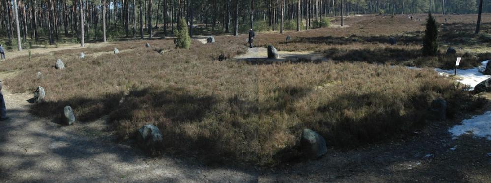
Fig. 1. General view of the site. Photo composite © Clive Ruggles
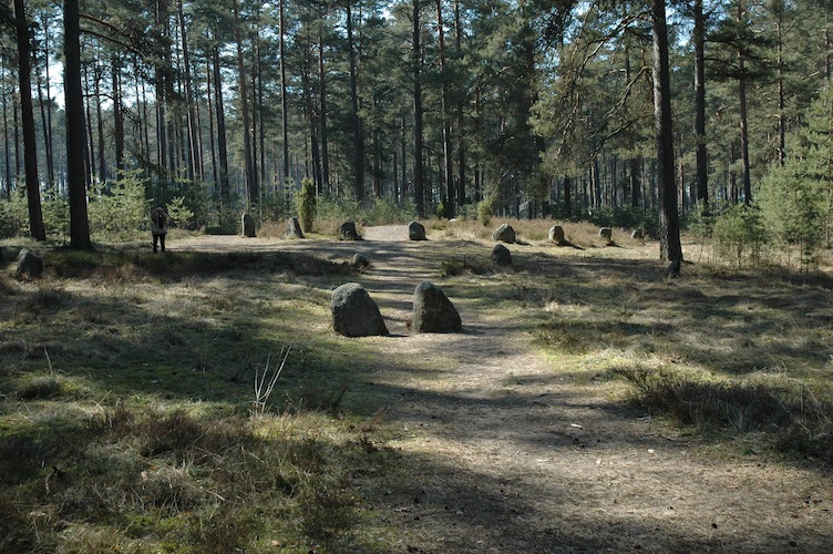
Fig. 2. General view of the site. Photograph © Clive Ruggles
History
The site was investigated in the second half of the 19th century by two amateur archaeologists, Wilhelm Stryjkowski and Abraham Lissauer, who excavated several burials, removed some of the stones, and concluded that the remains were Neolithic in date. Paul Stephan, a geodesist from Poznan, surveyed the site in 1915 and was the first to propose astronomical alignments. Jozef Kostrzewski (Poznan University) excavations the site in 1926 and was the first to date the stone circles correctly to the 1st and 2nd centuries AD.
Stephan discovered that sightlines connecting the central stelae of 4 of the stone circles point to the solstitial points, and also identified various stellar alignments on the (false) assumption that the construction date was in the 18th century BC. He therefore proposed that the Odry circles were carefully designed so as to establish a precise calendar, needed for tribal festivities. In the 1930s, Stephan’s interpretation of the Odry site was used by some Nazi archaeologists to demonstrate the supposed intellectual superiority of the Germanic tribes, and in 1940, after Germany’s capture of western Poland, the site was declared a ‘Germanic sanctuary’ under the curatorship of the special SS unit for archaeological excavations. One of the ramifications of this was to deter serious research for many years. In 1963, the historian of astronomy Jerzy Dobrzycki demonstrated conclusively that Stephan’s conclusions were undermined by Kostrzewski’s chronology.
The Odry site was systematically investigated in the 1960s by an archaeological team led by Jerzy Kmiecińsk (Łódż University). Following this, the site once again became a focus for archaeoastronomical research, and in the 1970s and 1980s Mirosław Dworak, Ludwik Zajdler, Mariusz Ziółkowski, Karol Piasecki and Robert Sadowski proposed different hypotheses regarding site’s astronomical alignments. Unfortunately, they never arrived at final and definite statements. In the 1990s and 2000s a new generation of archaeoastronomers have proposed that even the solstitial alignments might be fortuitous.
Cultural and symbolic dimension
The Odry site is associated with the cultural activities of the peoples who created the Wielbark Culture (German Willenberg-Wielbark Kultur). This archaeological culture, which is attributed to the appearance of Goths and Gepids from Southern Scandinavia, emerged during the early years of the 1st century AD in what are now Eastern Pomerania and the Lower Vistula. They also created several other stone circle sites, including Węsiory, Grzybnica, and Leśno. In the first half of the 3rd century, the people of the Wielbark culture abandoned their settlements in Eastern Pomerania and migrated or expanded eastwards and southwards.
Comparative analysis
No information supplied.
Authenticity and integrity
No information supplied.
Documentation and archives
No information supplied.
Management and use
Present use
The site is open to the public daily, except for Mondays, throughout the year. Well-marked routes allow tourists to approach the circles without damaging the forest. The Reserve can be reached on foot or by bicycle (using the green tourist route across the Tuchola Forest), or by kayak along the Wda River.
State of conservation
No information supplied.
Main threats or potential threats
Although the site is well protected, its use by various ‘New Age’ groups poses some potential threats. It is utilized both by groups who congregate here at the summer solstice for gatherings and rituals, and by people such as dowsers, ‘bioenergotherapists’ and others who believe it to be a source of cosmic energy.
Protection
A state decree of 1958 declared the site a Natural Reserve in order to protect at least 86 different species of moss and lichen that were found on more than 300 hundred stones and boulders. Today it is Archaeological and Natural Reserve protected under Polish laws relating to archaeological and natural monuments and covers an area of 17 ha (delimited in the foundation decree). The site is fenced.
Context and environment
The stone circles are located within a sparse pine forest near to the river Czarna Woda, a tributary to the Vistula. This forms part of the large Tuchola Forest (Bory Tucholskie), which covers 4789 ha (47.9 km²) between the Brda and Wda rivers in central-northern Poland. The forest contains sand dunes, small morainal hills and narrow postglacial lakes formed after the last (Würm) glaciation. In 1996, the most scenic core of the spruce and pine forest that covers the area today was designated the Tuchola Forest National Park. It contains wild boar, fox, fallow, deer, red deer, polecat, badger, wood grouse (in the more inaccessible thickets), herons, white and black storks, eagle owls, eagles and cranes.
Archaeological / historical / heritage research
No information supplied.
Management, interpretation and outreach
Tourist information and services are located in a kiosk by the site entrance. A guide service is available if requested in advance by telephone.
References
Bibliography (books and published articles)
- Dobrzycki, Jerzy (1963). ’Astronomiczna interpretacja prehistorycznych zabytków na terenie Polski‘, Kwartalnik Historii Nauiki i Techniki 8, 1: 23-27.
- Kotlarczyk, Janusz (1993). ’Kalendarzowe aspekty organizacji przestrzeni kultowej stanowiska w Odrach‘, in Wierzenia przedchrze┼øcijańskie na ziemiach polskich, edited by M. Kwapiński and H. Paner, pp. 128-136. Gdańsk: Muzeum Archeologiczne.
- Müller, Rolf (1934). ’Zur Frage der astronomischen Bedeutung der Steinsetzung von Odern‘, Mannus 26, 289-309.
- Müller, Rolf (1970). Der Himmel über dem Menschen der Steinzeit. Berlin: Springer-Verlag.
- Sadowski, Robert M., Mariusz Ziółkowski, and Karol Piasecki (1982). ’Stone rings of northern Poland‘, in Archaeoastronomy in the Old World, edited by Douglas C. Heggie, pp. 215-224. Cambridge: Cambridge University Press.
- Sadowski, Robert M. (1992). ’Odry Revisited‘, in Readings in Archaeoastronomy, edited by Stanisław Iwaniszewski, pp. 53-56. Warszawa: Państwowe Muzeum Archeologiczne.
- Stephan, Paul (1915). ’Vorgeschichtliche Sternkunde und Zeitenteilung‘, Mannus 7, 213-248.
Links to external sites
No information supplied.
Links to external on-line pictures
No information supplied.