Category of Astronomical Heritage: tangible immovable
Pic du Midi de Bigorre Observatory, France: English version

Identification of the property
Country/State Party
France
State/Province/Region
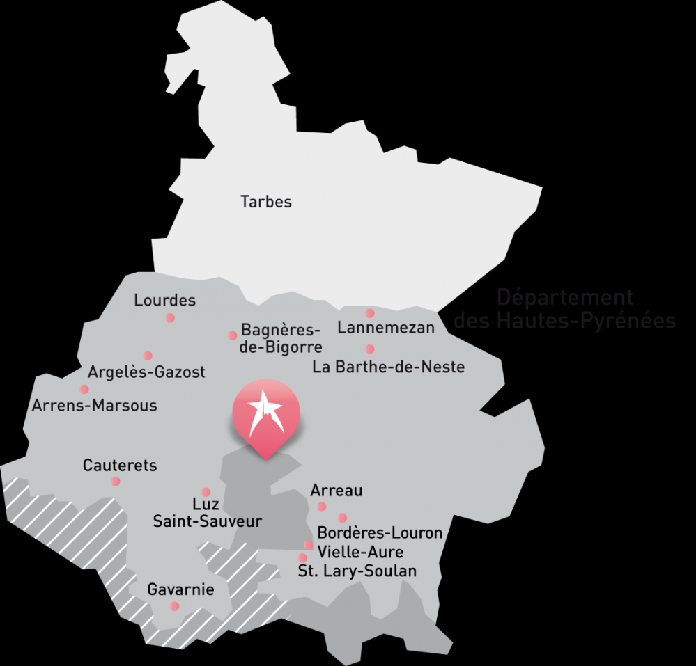
Midi Pyrénées Region, Hautes-Pyrénées Département
Name
Pic du Midi de Bigorre Observatory
- Observatoire du Pic du Midi de Bigorre VERSION FRANÇAISE

Photograph © Haute Pyrénées Tourisme Environnement
Geographical co-ordinates and/or UTM
Latitude 42.9374 N, longitude 0.14106 E
UTM (Zone 31N) E 266729 N 4757829
Elevation 2830m (GoogleEarth)
Maps and plans,
showing boundaries of property and buffer zone
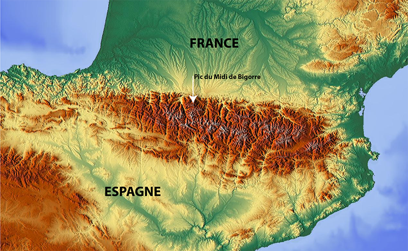
Fig. 1. Locality of the Pic du Midi de Bigorre within the Pyrenean Chain. Source: geographdumonde
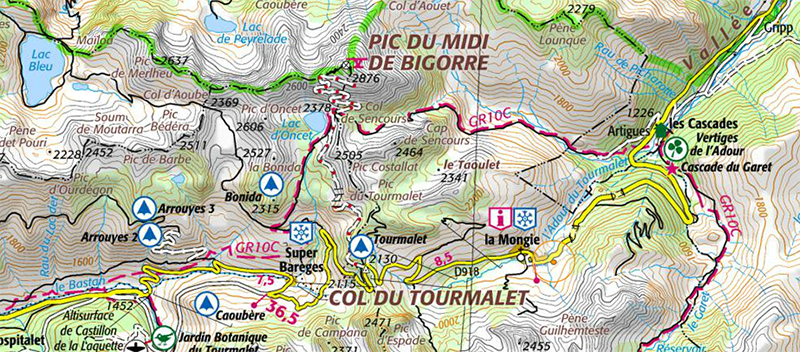
Fig. 2. Extract from the IGN map, scale 1:50,000. The cable-car line to access the Pic du Midi, leaving from La Mongie,
crosses over the Taoulet before reaching the summit. Source: géoportail
Area of property and buffer zone
The observatory takes up the entire surface of the Pic du Midi de Bigorre summit, that is 3500 m².
Description
Description of the property
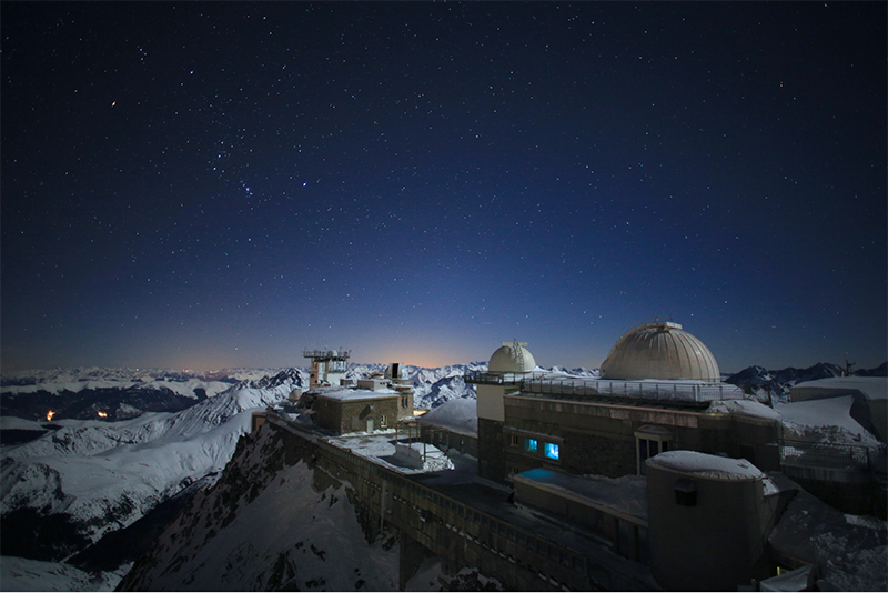
Fig. 3. The Pic du Midi de Bigorre Observatory by night, in December 2013, facing the eastern horizon. 2013. Photo © Nicolas Bourgeois
Introduction
The Pyrenees form a natural border almost 400 km long, both separating France and Spain and joining the Atlantic and the Mediterranean. As we approach this indented wall of snow-capped peaks, one of them immediately catches the eye: the Pic du Midi. Benefitting from an exceptional, seemingly privileged geological location, this mountain stands at nearly 3000 m above sea level in the line of the Pyrenean foothills. It thus appears to dominate all the mountains surrounding it.
The mountain’s very position and presence has long captivated mountain dwellers, and later scientists. It has been home to history and human adventure for hundreds of years. But as Graham Greene said, there is no beginning or end to history; it is because of arbitrary decisions that we fix it in the river of time.
As we continue towards the Pic du Midi, it is no longer the mountain alone which holds our attention, but the budding domes and grand aerial on its summit. Finally the Pic du Midi Observatory is revealed, a high-mountain scientific fortress that has stood strong for over 130 years.
Our arbitrary decision comes into play here. A new beginning, in 1870: the birth of the observatory and of human and scientific adventure. And now, not an end but an opening: 2014, the year in which the Pic du Midi decided to value and preserve what makes it an treasured inheritance, namely that it is the oldest mountain observatory still working today.
Despite its total isolation, the observatory has made significant contributions in a number of scientific fields that depend on findings at high altitude or in a very pure atmosphere. This is shown by data such as scientific results, publications and prizes, and the number of researchers who have succeeded one another. In so doing it has itself evolved, keeping pace with the development of scientific knowledge.
The unique identity of the Pic du Midi goes beyond the purely scientific realm. Above all, it is a matter of a human adventure that is still continuing today. It is this that accounts for the scale of the heritage described below.
Environment
The Pic du Midi de Bigorre, an exception in Pyrenean geology
The Pic du Midi stands at 2877 m. Nowhere on the northern side of the Pyrenees is there another mountain of comparable altitude so close to the plain. The surrounding peaks reach 2500 m at best.
The Pic du Midi owes this characteristic to its geological structure. The rocks that form the pyramid are variable in nature: limestone massif, silicate minerals and schist on the top. This combination has been very much affected by intense metamorphism (the rocks have undergone temperatures of 600°C at pressures of tens of kilobars). The result of this metamorphism was a hardening of the rocks, a recrystallising of them. The limestone massif thus became more resistant to erosion than its surrounding neighbours.
Another outstanding result of the metamorphism is the presence of geological formations known as “barégiennes”, in reference to the local town of Barèges. The barégiennes appear to be significant distortions of the geological domain. They are derived from the alternating siliceous beds (which deform rigidly) and carbonate beds (which deform plastically) having been subjected to the increase in temperature and pressure that occurred during the Hercynian period. These barégiennes look like huge, stone snakes and are at the origin of the tale of the legend of Python, the guardian of the Pyrène tomb.

Fig. 4. The Pic du Midi and the Observatory, aerial view, 2010. Photo © Haute Pyrénées Tourisme Environnement
The atmospheric quality and the scale of the panorama
The geological characteristics of the Pic du Midi mean that it benefits from two major assets: excellent atmospheric quality and stability, and a spectacular panoramic view.

Fig. 5. The Pic du Midi above the sea of clouds, 2009. Photo © Pierre Paul Feyte
The Pic du Midi’s altitude rises above the lower layers of the atmosphere where we find dust, droplets and other particles. The summit is situated in the lower troposphere, an atmospheric layer that establishes itself between 2500 and 3500 m above sea level, reversing the natural temperature curve and keeping condensation blocked below. When this limit of this layer is below the summit, the observatory stands above a sea of clouds, allowing access to a sky entirely devoid of particles and light pollution.
The position and elevation of the peak have another beneficial effect: atmospheric stability. The dynamics of the layers of air found in the upper troposphere (3000 to 10,000 m above sea level) depend upon geomorphology. A mountain causes turbulence in much the same way as a stone falling into water disturbs the water’s surface. However, when the wind comes from the north or north-east, the first mountain that the air mass reaches is the Pic du Midi. The flow of the airstream is thus laminar, with no turbulence between the summit and the stars.
It was this exceptional atmospheric quality that the first Pic du Midi astronomers took note of in the early twentieth century, and which continues to allow us to conduct many research programmes on the properties of the atmosphere.
From the summit, which rises up above all surrounding landmarks, one enjoys an exceptional view. Count Russel liked to say that from the peak you could see the foothills of the Massif Central by day and the lights of the Biarritz lighthouse by night. His successors, contemplating this, could only confirm it.
The characteristics of this view are such that in 2003 the Pic du Midi was registered by the French government for the beauty of its landscapes. Indeed, on a clear day, the spectacular view offers up all 400 km of the Pyrenean chain.
The properties of this natural viewpoint were, in a way, the first foundations of the Pic du Midi Observatory. Almost a century and a half later, it continues to use them in order to enrich both science and mountaineering in the Pyrenees.
Intangible heritage
The Pic du Midi Observatory’s contribution to the scientific knowledge of humanity over the 130 years it has existed is very rich indeed and covers a wide range of natural sciences.
The Pic du Midi has been and remains a first class astronomical site owing to the quality of the seeing and the transparency and purity of its sky both by day and night. This quality is now guaranteed by the commitment of all the people working to preserve the sky above the peak following the recognition of Pic du Midi as an International Dark Sky Reserve in 2013.
The Pic du Midi plays a central role in spreading knowledge to visitors from around the world, as much about the quality of its preserved geological landscape as the quality of its night sky. This is open to professional astronomers, amateur astronomers, university students, schoolchildren and the general public.
The use of the Pic du Midi as a place of scientific observation is rooted in the Enlightenment period, well before any building took place on the summit. Some of the great names in exploration made some interesting observations from the peak. These observations were used in developing the topographical map of France and for pioneering new ways to measure atmospheric pressure at altitude (Cassini III in 1740; Monge and Darcet in 1774; Lapeyrouse in 1782).
The Pic du Midi is known worldwide for many modern discoveries, including the following:
Aerology
- The first measurements of ozone at high altitude using chromatography (Marchand in 1874 and 1909). These measurements serve as a reference for the contemporary evolution of anthropogenic ozone pollution (tropospheric increases evaluated over 100 years by the current service). The Pic du Midi remains an international reference site for the quality of the troposphere, chemical measurements of CO, CO2, O3, NOx, mercury vapour, aerosols, and mass spectrometry of traces of radioactive elements (Pyrenean Atmospheric Observation Platform: Gheusi in 2012). The Pic du Midi detected, using mass spectrometry, traces of radioactive elements from Fukushima six months after the accident in 2012 (Van Beek in 2012).
- Pioneering studies of atmospheric electricity and lightning (Dauzère in the 1920s and 1930s). The Pic du Midi is now an international site for the study of Transitory Luminous Phenomena (or Sprites): these are the flashes that appear above thunderstorms (Soula in 1990).
Cosmic rays and particle physics
- The first measurements of cosmic rays and atmospheric electricity (Nodo in 1907) five years before the discovery of cosmic rays by V. Hess in 1912.
- The Pic du Midi became a hotspot for research on cosmic rays (Daudin, 1948–53) and particle physics after preliminary measurements (Cosyns from 1937; Auger in 1938). The site welcomed international teams managed by P. Blackett (Nobel Prize, 1948)—it was the location for the fundamental discoveries of the pion (pi meson) by Occhialini in 1947 and the hyperon in 1950—and then Leprince-Ringuet (1951–53) with the installation of a bubble chamber and particle physics detector. The Pic du Midi was the main site for research in this area up until the foundation of CERN in 1958.
- The study of cosmic rays is experiencing a revival at the Pic du Midi with the recent installation of a Bonner high-resolution, spherical spectrograph (Hubert in 2013, ONERA, INRS) for studying the spectrum of telluric and cosmic neutron disintegration.
Solar Astronomy
- Pioneering photographs of the eclipse of 18 July 1860 by Maxwell-Lyte from the meteorological station in Sencours; observations of the low solar corona using the coronographic technique, a technique invented and tested by Bernard Lyot at the Pic du Midi from 1930 to 1940. See the Paris Observatory’s digital base, notably the first films of the solar flares taken by Lyot between 1935 and 1937 and films on sunspots and solar granulation by taken by Lyot in 1943.
- Pioneering discoveries on solar granulation: the most precise solar observations from Earth using the Jean Rösch Telescope from 1961 to 1990. Also, the work of R. Muller on observations within the G band wavelength range (430.5 nm) at very high resolution (seeing = 0.3 arc sec) and that of T. Roudier and M. Rieutord on the dynamics of sunspots and magnetism (1990–2009).
- Today, the solar corona observation service continues to observe the Sun with a Lyot coronograph (rebuilt in 2009), continuing a tradition that began almost a century ago on the Pic du Midi. The findings are stored in international databases managed by the Observatoire Virtuel du Grand Sud Ouest, for the use of astronomers worldwide.
Planetary Astronomy
- Observations of planetary surfaces (Henri Camichel, Audoin Dollfus, Jean Focas, Edward Bowell and John Murray, 1943–1963): some of the best images of the planets in our solar system taken from the Earth have been produced using the 60 cm Telescope in the Baillaud dome and then the 1m Telescope. The measurement of planetary diameters; the measurement of the retrograde rotation of Venus’ atmosphere (Boyer 1957-1967). The mapping of the moon and preparations for the Apollo mission (1964–1966: over seventy thousand shots, Manchester Lunar Programme).
- Pioneering measurements of the distance between the Earth and the Moon using laser shots (Calame in 1969).
Stellar Astronomy
- Today, the Bernard Lyot Telescope (2m) is the worldwide leader in the observation of stellar magnetism using the instruments MUSICOS (Boehm, Catala, Donati 2000-2007) and NARVAL (Semel, Donati, since 2007). Many pioneering discoveries were made and continue to be made in the study of magnetic fields across the HR diagram.
- Current projects are moving towards monitoring the impact of magnetic fields on exoplanetary systems both nascent (SPIP project, Donati) and at the end of their lives (Boehm, Neo-Narval).
Instrumental Development
- The Pic du Midi has served, and continues to serve, as a testbed for many different instruments. Examples include developments in coronography (a technique invented at the Pic du Midi by Bernard Lyot in 1930-1931) and polarimetry (pioneering instruments were developed by French teams—Semel, Leroy, Donati), and the first CCD, now in use in digital photo devices. Semiconductor matrix detectors have been most notably developed and tested by Toulouse teams at the Pic du Midi (Strong in 1980). The early development of instruments that correct for atmospheric disturbances (telescopes isolated from dome turbulence, Lyot, Rösch; Prieur tavelograph, 1991–1993) also took place at Pic du Midi.
Tangible heritage—a partial inventory
Immovable items—buildings and grounds
The Pic du Midi Observatory building represents the culmination of 140 years of organisation and development, resulting in a complex and massive infrastructure which has been devoted to science and also, since the 2000s, to tourism.
The general architecture of the Observatory is a direct result both of this long history and of the continuity in its function. There is typical mountain architecture (ogival roofs and walls built of stone extracted from the summit itself) but also, uniquely, more contemporary architecture, developed and designed specifically for the Pic du Midi (the Jean Rösch dome and the Bernard Lyot Telescope observatory).
The size, complexity and diversity of the activity on this platform oblige us to focus solely on the heritage developed on the summit, but elements such as the Plantade Station on the Col de Sencours and the Observatory of Bagnères de Bigorre were fundamental elements of the Pic’s life.
Evidence of the desire to preserve the heritage of the Pic du Midi can be found in the excellent conservation of the scientific buildings, which is largely due to tourist activity. Our description will therefore focus on these buildings.
The key periods in the evolution of the infrastructure are presented in the “History and development” section below.
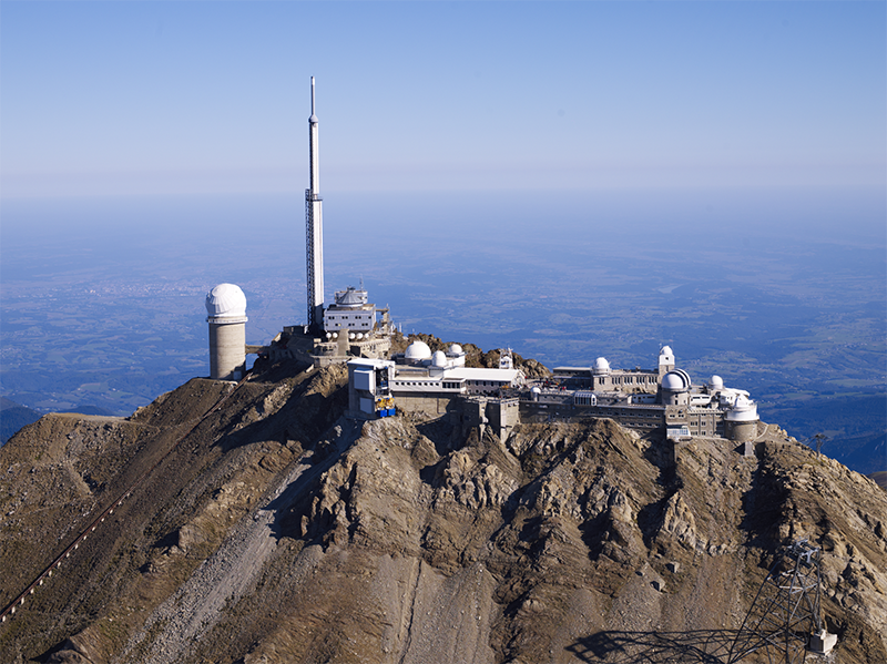
Fig. 6. Aerial view of the Observatory after the “Pic 2000” project in 2000. The new elements of infrastructure are visible: the cable car station, the footbridges, the new coronograph building, and the modernising of the weather tower (2009). Photo © Claude Etchelecou
General description and key facts and figures in the Pic du Midi’s tangible heritage
We can imagine the Pic du Midi to be a small independent town perched on a peak at almost 3000 m above sea level. The general description that follows expresses this idea.
The Pic du Midi comprises:
- A terrace covering 750 m²
- 5 km of inland corridors for link buildings and basements
- 10,000 m² of covered surfaces
- 5 floors (8 if we include the floors in the Interdepartmental building: the equivalent of 10 storeys)
- Annual electricity consumption equal to that of a French village of 600 people
General infrastructure
On the summit this is of three types: scientific infrastructure (buildings and observatories); tourist infrastructure (museum, restaurant, reception and constructions for managing the movement of people); and the Interdepartmental building and its aerial.
The scientific infrastructure and tourist infrastructure are interdependent whilst remaining dissociated. The observatories are only accessible to tourists under certain conditions and on certain occasions, in order not to disrupt their scientific activities.
The platform consists of the following:
- 4 scientific and historic buildings on the terrace: the Vaussenat building, the Nanssouty building, the Marchand laboratory, and the Dauzère building.
- 7 astronomical observatories, 5 of which house scientific instruments that are still in use: the Bernard Lyot Telescope dome and observatory, the 1 m Telescope dome and observatory, the Jean Röcsh dome and observatory, the Coronograph dome and observatory, the 60 cm Telescope dome and observatory, the Charvin dome and, finally, the Baillaud dome.
The scientific buildings of the Pic du Midi Observatory
The Baillaud Dome (1908)
The Baillaud dome was the initiative of Benjamain Baillaud, the director of the Toulouse Observatory at the beginning of the century. It was the first permanent astronomical facility to be installed on the Pic du Midi. Almost unused until the 1930s, it later became the centre of the Observatory’s astronomical activity. Indeed it was under this dome that Bernard Lyot invented and subsequently tested his coronograph. Later, in the 1950s, the dome housed powerful instrumentation, allowing us to take advantage of the transparent sky above the Pic du Midi. The Pic du Midi’s international prestige originated from the Baillaud Dome. Most of the scientific discoveries and contributions towards both planetary science and the study of the sun were made in this building.
Between 1904 and 1905, the dome was built and assembled for the first time in Toulouse, in the gardens of the Jolimont Observatory. During 1906 and 1907, it was transported first by train, then by men and mules, to the summit. On 14 September 1907, the dome was finished. Measuring 8 m in diameter, the dome is large enough to accommodate a 500 mm telescope with a 230 mm guider on the top.
For nearly 130 years, the Pic du Midi has been expanding with further constructions being added around the first domed buildings. In the late 1990s, the Baillaud Dome ceased its scientific activity. Preserved in its original state, it is now the highlight of the observatory museum space. Presented here for visitors are Lyot’s first coronograph and other instrumentation.
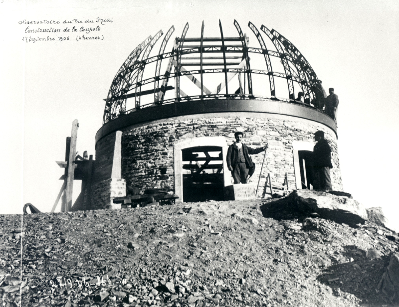
Fig. 7. Construction of the Baillaud Dome in 1907. Photo © Alix, Fond Eyssalet
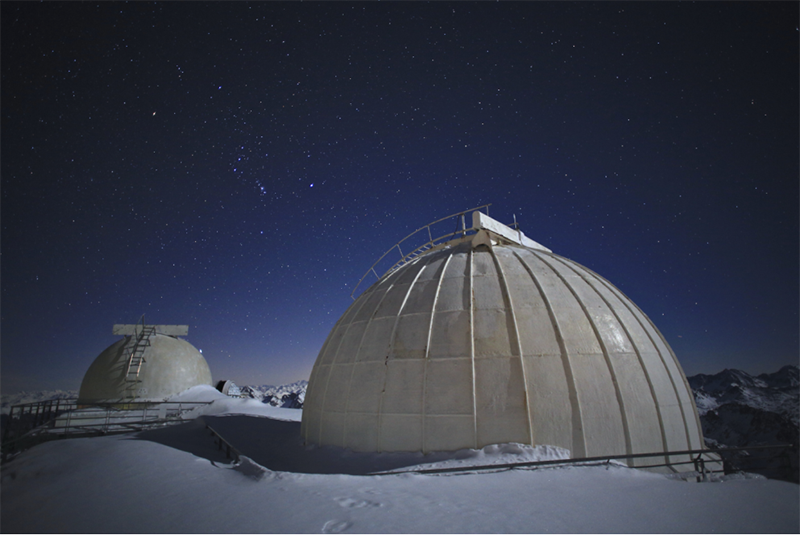
Fig. 8. The Baillaud Dome in 2013. It houses the museum and the 1/1 scale model of the coronograph. Photo © Nicolas Bourgeois
The 1m Telescope Observatory and Dome (1947)
The 1m Telescope dome has been at the summit since 1947. Made in 1925 and based in Paris, the dome was donated by Marcel Gentili, in recognition of the years he spent on the Pic during World War II, where he was protected from the Nazis. This dome, installed on the Dauzère building, originally housed the Gentili 60 cm telescope.
In March 1962, the new 1m Telescope was installed to support the Manchester Lunar Programme. At this time, use of the dome proved to be an excellent opportunity for the NASA-financed programme. Indeed, the experience gained on the Pic du Midi concerning the necessary conditions to obtain good images allowed us to highlight the need for a small dome so that the thermal balance between the instrument and the air outside/inside would take place quickly. Owing to a lack of resources to build a new dome, Gentili’s gift was accepted and served only to reinforce the project.
This dome, which today is over a century old, has housed one of the Pic du Midi’s most efficient instruments for 50 years: the 1m Telescope.

Fig. 9. The Dauzère building, where the Gentili dome was placed in 1947. Photo © Alix, Fond Eyssalet

Fig. 10. The Dauzère building and the Gentili dome in 2013. The integrity of the building has been fully preserved. Photo © Nicolas Bourgeois
The Jean-Rösch Dome and observation point, or Tourelle dome (1961)
The Tourelle dome is one of Jean Rösch’s pioneering and experimental projects at the Pic du Midi. This observation point complements and reinforces the work following the sun done under the Billaud dome. Rösch’s ambition was to create a unique type of observatory in order to benefit from the high atmospheric quality that the Pic offers whilst reducing the constraints inherent to solar observation with a conventional device (increase in dome temperature, image deterioration due to instrumentation, internal turbulence).
In order to create this dome, Jean Rösch called upon Jacques Pageault. Pageault designed and constructed the dome in the Bagnères Observatory workshop.
The dome has been installed on the extreme eastern end of the summit, which is the ideal place to make the most of observational conditions in the morning, the best time of day. The dome was inaugurated on 15 February 1961, a day when a partial solar eclipse was visible.
The dome measures only 5 m in diameter, but its design is such that it can accommodate an instrument 6 m long. The instrument’s lens is 2.5 m outside the dome, which allows it to escape the structure’s internal turbulence. It is also equipped with a cooling system for draining away the energy produced by the light beam. In addition, the interior walls of the dome are isolated by a lining. The characteristics of this dome have been included in most solar telescopes built around the world subsequently.
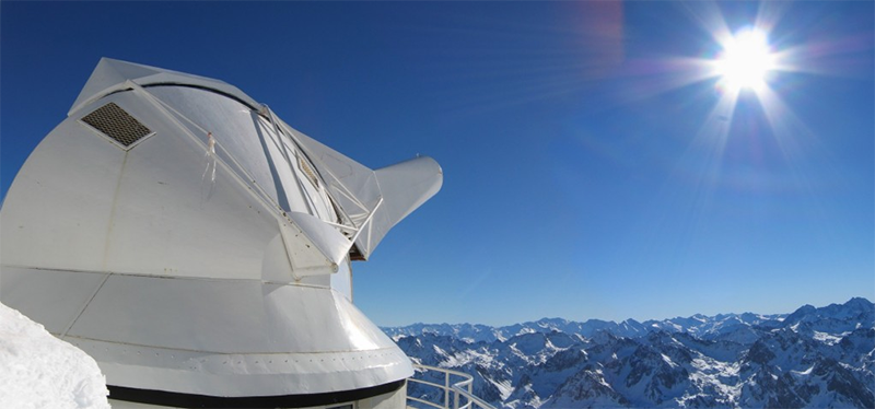
Fig. 11. The Tourelle dome was installed on the extreme eastern end of the Pic du Midi platform in order to make the most of optimal observation conditions early in the day (2013). Photo © Régie du Pic du Midi and Observatoire Midi Pyrénées
The Bernard Lyot Telescope dome and observatory (1978)
The Bernard Lyot Telescope dome and observation point were developed by Jean Rösch’s team in order to accommodate the largest national telescope. This project came into being in 1966. Its location and architecture were determined by two conditions which are dear to the Pic du Midi astronomers: maximum use of the atmospheric stability offered by the Pic du Midi and creating the best possible balance between the structure and the instrument it houses (in the manner of the Tourelle dome and the Jean Rösch Telescope).

Fig. 12. The Bernard Lyot Telescope tower and dome. The cap is open and pointing eastward. The building is located to the south-west of the summit (2013). Photo © Régie du Pic du Midi and Observatoire Midi Pyrénées
In order to take advantage of all the benefits the summit has to offer, the position of the structure was determined using a wind tunnel. This was the first time such a method was used in deciding where to place an astronomical site. Following this analysis, the south-west of the summit was chosen. In order to escape the turbulence caused by the floor heating up during the day, it was decided that the dome should be placed on a tower 28 m high and 14 m in diameter. The tower has 5 floors, the first floor being the room for aluminising the telescope mirror.
The dome’s characteristic form is explained by Jean Rösch’s desire to minimise the disruptions linked to air exchange between the instrument and the inside/outside air. To do this, Jean Rösch wanted to connect the telescope tube directly to the dome opening, which explains the very small size of the latter. Due to a lack of budget, and a disagreement between the team and future users of the instrument, this technical solution did not turn out well. In order to preserve the quality of the image, engineers applied the solutions adopted in Hawaii to the Observatory telescope: a cooled floor and perforated tube.
This imposing structure was built between 1970 and 1978. The building site proved extremely difficult because of the conditions imposed by the high altitude.
This building is a product of the modern era of astronomy. It means that today the Pic du Midi is a pioneer in observations of stellar magnetism and maintains a leading position in international research.
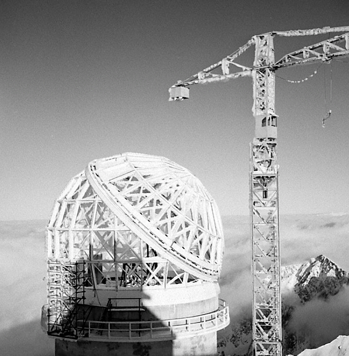
Fig. 13. The construction of the dome in 1974. The difficult conditions of the mountains are clearly visible: frost covered the buildings and the construction machinery. Photo © Régie du Pic du Midi and Observatoire Midi Pyrénées
Movable heritage objects—telescopes
The first coronograph in the world, invented by Bernard Lyot in 1933

Fig. 14. The first coronograph in the world. Invented and tested by Bernard Lyot at the Pic du Midi. It is displayed in the museographic space in the observatory (2013). Photo © Régie du Pic du Midi and Observatoire Midi Pyrénées
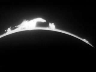
Fig. 15. Image from a film of the solar corona taken by the Pic du Midi chronograph in 1935. Photo © Vidéothèque du CNRS
This coronograph was invented and tested during the 1930s. The first films and images of the solar corona were created by Bernard Lyot at the Pic du Midi as early as 1935.
The 60cm telescope (1922)
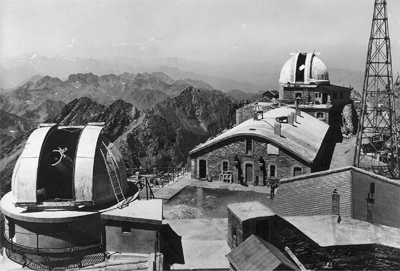
Fig. 16. The 60cm Telescope in 1947 (on the left of the picture). At this time, it was placed under the dome that would house the 1 m Telescope. Photo © Alix, Fond Eyssalet
The T60 was installed in 1947 at the Pic du Midi. At the time, it was the instrument with the greatest diameter in the observatory. Today, it is the oldest telescope still in working order. In the 1950s, it was used mainly for photometry. With the arrival of the 1 m Telescope in 1963, the T60 was placed in the smallest dome on the same floor as the terrace and was principally used for the study of extragalactic nebulae. In 1982, the Toulouse Observatory created a committee of amateur and professional astronomers who would manage the new research programmes for the T60. This initiative allowed us to test the participation of amateur astronomers in professional research programmes. Given the success of this initiative, the T60 association was created in 1985. Today, an important associative network supports the association responsible for maintaining and developing the operation of the telescope. Incidentally, it was on the T60 that the first CCD amateur camera was placed in 1985.
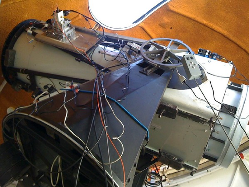
Fig. 17. The 60cm Telescope and its modern equipment (2012). Photo © Association T60
The Jean-Rösch telescope (1961)

Fig. 18. The Jean Rösch Telescope 50cm lens (2012). Photo © Observatoire Midi Pyrénées
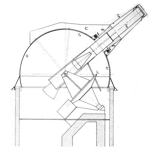
Fig. 19. Plan of the Tourelle Dome and Jean Rösch Telescope. It can be seen that these two together form one single instrument. Photo © Observatoire Midi Pyrénées
The current Jean Rösch Telescope (JRT) is the result of several years of evolution. It is used to observe the photosphere (solar surface) at very high resolution. The distinctive feature of the instrument lies in the originality of its construction. It is directly linked to the structure that protects it: the Tourelle dome. It is the combination of the telescope and dome, as it were, that forms the real instrument. We have already described the Tourelle in the previous section.
The JRT was initially equipped with a 38 cm lens, but in 1972 Jean Rösch received supplementary funds to increase the strength of the lens. A 50 cm lens was fashioned in the Observatory in Paris by Jean Texereau. This lens is today considered the masterpiece of the optician’s career. Up until 1987 the JRT, associated with the atmospheric qualities of the Pic du Midi, was the best performing instrument used to observe the sun in the world.
The research carried out by the JRT in the 1970s had an important impact on the evolution of solar physics, especially on the interaction between granulation and the cycles of solar activity.
The JRT today forms part of an international solar observation network, on the ground and in space. The largest instrumentation field of the telescope has no competition for the time being, which allows it to remain complementary to major international space observatories.
The 1 m Telescope (1962)
As with the JRT, the T1M benefitted from several instrumental improvements over the course of its history. NASA encouraged its construction in 1959 so as to increase the instrumental power of the Manchester Lunar Programme and thus to obtain the best possible images of the moon for the Apollo Programme Lunar Atlas. In 1974, the old optics were replaced by a new Pyrex mirror built by Jean Texereau, one made from a material that is not too sensitive to heat.
During the telescope’s first ten years of service, it was used in inverse mode as a transmitter as well as a receiver of light. A network of great scientific institutions created a project (École Polytechnique, CNES, CNRS) whose goal was to measure the distance between the Earth and the moon by firing a laser. The first echoes were measured in 1969 following the placing of reflector panels on the moon by the Apollo 11 astronauts.
Today, the T1M is equipped with a CCD camera and is managed by the Institut de Mécanique Céleste et de Calcul des Ephémérides in the Paris Observatory. It is used to study the planets and small bodies of the solar system.
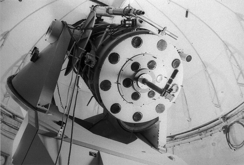
Fig. 20. The 106 cm Telescope in the 1950s. It is equipped with material for silver shots using its cassegrain focus. Photo © Observatoire Midi Pyrénées
The Bernard Lyot 203cm Telescope (1976)

Fig. 21. View of the interior of the Bernard Lyot Telescope dome. The red structure is the horseshoe-shaped setting which supports the 2 m telescope. The NARVAL system can be seen, installed at the telescope’s focus (2009). Photo © Paul Compère
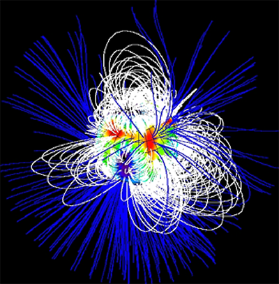
Fig. 22. Model of the magnetic field of Star SU Aurigae, created using the NARVAL and ESPADON systems (2007). Photo © Observatoire Midi Pyrénées
The Bernard Lyot Telescope is considered by its founders the greatest achievement of the human and scientific adventure at the Pic du Midi. Even though the difficulties faced during its development and creation meant that the initial project could not be carried out, the Bernard Lyot Telescope remains today the most important telescope on French soil and occupies a unique place on an international scale.
The double focus telescope (cassegrain focus open at f/25 and strand at f/5) is installed on a 16-ton horseshoe-shaped structure resting on an oil bath.
During the first 30 years of its service, the BLT was a generalist instrument used to serve the international astronomical community (infrared-visible imagery, photometry, polarimetry, spectroscopy). In 2006, the BLT was equipped with a spectro-polarimeter, named NARVAL, installed on a network with the Canada-France-Hawaii Telescope for continuous monitoring.
Thanks to NARVAL and the BLT, the Pic du Midi Observatory is currently the most important contributor in the study of stellar magnetism. Among its key findings are the characterisation of the magnetic field of various stars (small and massive) and the inversion of the magnetic field in several stars.
Finally, the BLT was one of the main factors that led astronomers and public workers to initiate the Pic 2000 project and thus save the scientific work of the observatory.
Movable heritage objects—small instruments, books, archives and photographs


Fig. 23. Extracts from the inventories of the Pic du Midi’s heritage objects. Images: Ramond Society Heritage Fund in Bagnères de Bigorre. Photo © Société Ramond
All small items, books, archives and photographs related to the Pic du Midi are preserved in various heritage collections and are currently undergoing an inventory.
These pieces of heritage are shared between the National Centre for Scientific Research (CNRS), the Paris Observatory, the Heritage Commission of the Midi Pyrénées Observatory, the Departmental Archives of Tarbes, the Ramond Society Heritage Fund in Bagnères de Bigorre, and the Eyssalet Photography Fund which is part of the Haute-Bigorre Community of Communes.
A common fund is being created in order to bring these iconic pieces of heritage together and thus display them in the museum area of the Pic du Midi.
History and development
140 years of life and science in the high mountains

Fig. 24. The Plantade station on the Col de Sencours in 1875. The summit of the Pic du Midi in the background is still devoid of any development. Photo © Alex, Fond Eyssalet
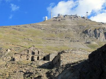
Fig. 25. The same view as in Fig. 9.24, in 2013. The Plantade station is currently in ruins and undergoing renovation. A hundred and forty years on, the most important working observatory in France stands on the summit of the Pic du Midi. Photo © Nicolas Bourgeois
The history and development of the Pic du Midi Observatory are primarily guided by three ideas.
The first is a contemporary mountain approach, which asserted itself in the 19th century. For members of the Ramond Society, the founders of the Observatory, the Pyrenees represent a world created to defy temerity, elevate the soul, explore and discover. This culture may explain in part the many risks taken for the good of the observatory.
The second is that the Pic du Midi, by its very geographical position and its atmospheric quality, has seen itself become a centre for research and a science hub. Even if astronomy later became an important uncontested element, science itself has reigned for over 60 years. The observatory is also a scientific platform where various different domains of research are carried out: meteorology, climatology, cosmic rays, botany, medicine, etc. This led to the significant development of the Pic’s infrastructure in order to meet the influx and expectations of a growing number of increasingly diverse researchers.
Finally, the Pic has always been threatened. Whether by the ever-difficult mountaineering conditions, budget constraints or competition from major international observatories, the growing threat of closure is very real indeed. But the Pic has always resisted. From the first stakeholders to the scientists and finally to the elected officials, there has been a chain of supporters and a human adventure continuously upholding this threatened heritage.
We will address the Pic du Midi’s history in six periods, through the facts, events and the scientific work. Details of dates, facts and scientific results will be accompanied by a mention of the key people that shaped the Pic and built its history.
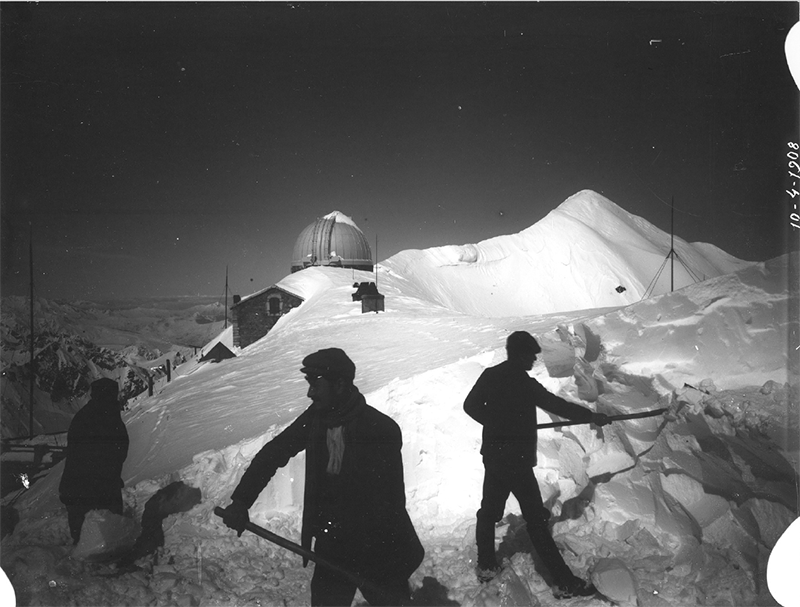
Fig. 26. The men’s ongoing battle on the summit during the winter of 1908. Photo © Régie du Pic du Midi and Observatoire Midi Pyrénées
From Genesis to the first stone (1865-1891)
The question of building an observatory on the summit of the Pic du Midi arose in the 18th century. But it was in the mid-19th century that the project really started to take shape thanks to members of a newly formed Pyrenean company: the Ramond Society. Its founders define it as a Pyrenean exploration company, grouping together scientists and mountaineers. For these men, the Pic du Midi would be the perfect host for a high-quality observatory. France learned about the impending creation of the observatory in 1869 via the Official Journal.
The war of 1870 caused the project to be suspended, then two years later, added weight to the argument that the work should restart: indeed in a country bruised by defeat, the observatory presented a way of raising the morale of the French people.
Two men will forever mark the history of the Pic du Midi. This is because they are at once the founders of the observatory and the guarantors of its Pyreniste identity. They are General Charles Champion du Bois de Nanssouty and the engineer Célestin-Xavier Vaussenat. Thanks to their efforts and research grant, the Pic du Midi project was voted in on 8 April 1873 and it was executed on 21 May 1878. Thirty workers worked on the summit until 1881, under the direction of General Nanssouty’s wife, Lucie Abadie.
On 27 July 1882, Vaussenat and Nanssouty donated the observatory to the French State in order to ensure its management, obtain finance and reimburse the debts. Xavier Vaussenat died on 16 December 1891, a date that marks the end of the first period in the history of the Pic du Midi.
Scientific work and results
During this period, the Pic du Midi was the centre for many experiments and meteorological readings, in particular for the central weather bureau.
Many of these experiments proved and presaged the quality of the observations that it would be possible to carry out.
The first decade of the Pic du Midi Observatory was thus a period of material expansion. Vaussenat, as well as setting up and securing the site, also contributed to publicising the summit by inviting scholars there during the summer period.
Infrastructure
In 1882, the observatory comprised a house (the Nanssouty building) connected to a small building by a narrow path (the future Vaussenat building), leaning against a blockhouse where the weather instruments were installed. A blacksmith’s, a stable and some shops were also built on the summit.
Celestin Vaussenat, up until his death, sought to level out the peak and build sheltered passages to facilitate travel in winter, when snow covers the station.
Work at this time was only possible for three months each year, from July to September, when there was no snow on the summit and the caravans and mules could access it.
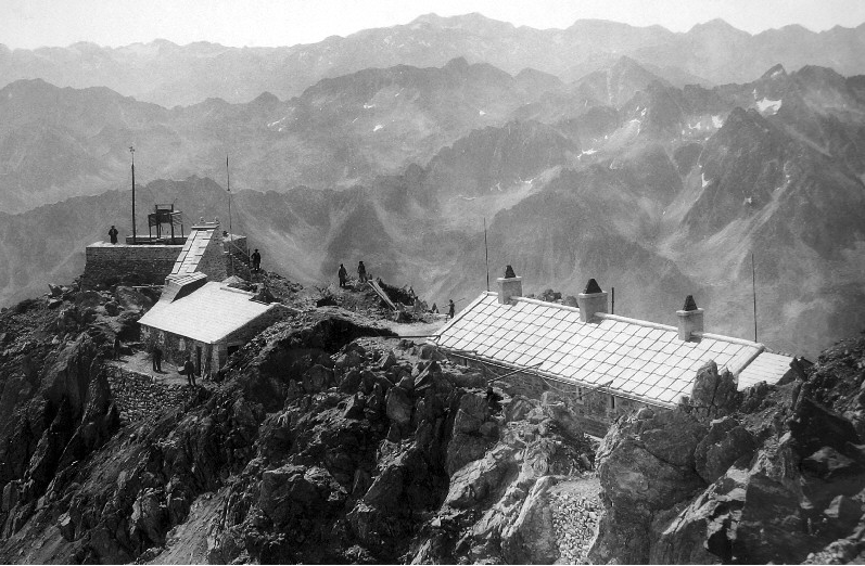
Fig. 27. The Pic du Midi Observatory in 1891. From left to right; the blockhouse, the Vaussenat building and the Nanssouty building. The construction of the terrace had not yet begun. Photo © Régie du Pic du Midi and Observatoire Midi Pyrénées
Systematic observations and the trials of the First World War (1892-1920)
From the arrival of the new director Emile Marchand in 1892 onward, the Pic gradually became a centre of multidisciplinary scientific observations, for which data in meteorology, atmospheric physics, seismology, astronomy and botany would be collected daily.
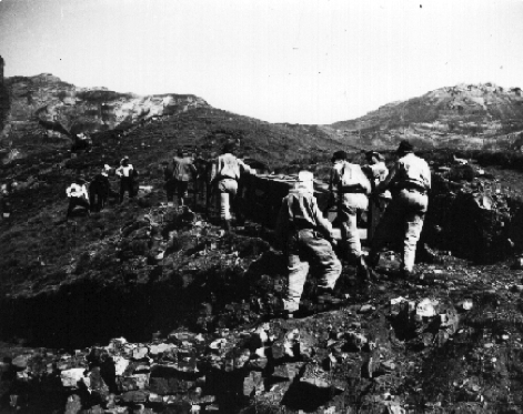
Fig. 28. The men from the infantry regiment in Tarbes carrying the Baillaud Telescope materials up to the summit (1906). Photo © Régie du Pic du Midi and Observatoire Midi Pyrénées
In 1900, the Pic saw the arrival of the Toulouse Observatory and its director, Benjamin Baillaud, who would encourage the building of the first dome and its grand telescope.
The Pic du Midi had a hard time during the First World War (1914–1918). Emile Marchand died in 1914 and so the Pic found itself with no director and no maintenance, a state of abandonment from which it only insecurely emerged in 1920 with the arrival of its third director, Camille Dauzère.
From 1903 to 1908, the main stages of construction of the first astronomical observatory of the Pic du Midi took shape. In 1906, the dome was built on the summit. After this the 50 cm Telescope, built in a Parisian workshop, was brought by rail to Bagnères, then by oxen and cart to the Col du Tourmalet. From there, a dozen soldiers of an artillery regiment from Tarbes were to persevere for more than a year to get the 22 boxes of material up to the summit.
In September 1907, the telescope was atop the Pic; another summer would be required to assemble it and make it operational. During the first 20 years of its use, the astronomical observatory held a place that was both paradoxical and representative of the Pic du Midi’s history. The observations made there were considered to be excellent. But the conditions faced by the observers (cold, snow, difficult access, temperamental weather), were such that motivated astronomers were rare indeed. The telescope remained practically unused until the 1930s.
Scientific work and results
During the 22 years of his directorship, Emile Marchand and his teams collected a considerable number of daily measurements: the mapping of the Sun, planetary surfaces and cloud cover, meteorological recordings, atmospheric electricity, terrestrial magnetism and seismology.
During this time, Marchand published 35 articles on geophysics, 20 on astronomy, 9 on botany and 6 on the relationship between the Sun and the Earth. Unfortunately, most of the articles only appeared in the journal of a local society and in progress reports for conferences.
We must go beyond the “anonymous” nature of these results in order to see the emerging intensity of observation at the Pic du Midi, foreshadowing its arrival at true scientific maturity from 1920 onwards.
The thirty years described here mark a new complexity and intensity in the history of the Pic du Midi. The observatory gained a paradoxical reputation. Its size and potential fascinated people, but equally it repulsed them with the tough conditions it imposed on them and their observations.
Infrastructure: landscaping, development of means of observation, construction of the Baillaud observatory building
Before the First World War, the main construction efforts were turned towards increasing the effective surface area of the Observatory by landscaping, and the development of its instrumental capabilities. The greatest additions to the Pic du Midi’s infrastructure at this time were the installation of the astronomical observatory in 1908, with the Baillaud Dome, the 50 cm Telescope and a building for accommodating astronomers.
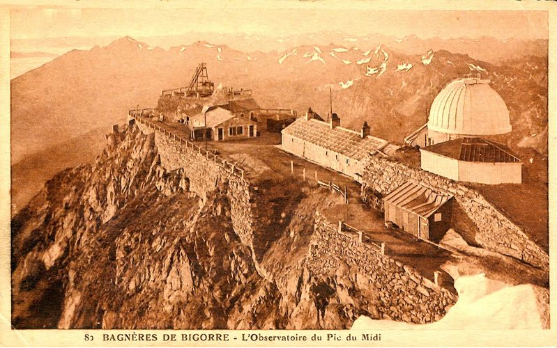
Fig. 29. The Pic du Midi Observatory just after the First World War. We can see the Baillaud dome and observatory building on the right, built between 1906 and 1908. The north terrace crumbled following several years without maintenance (1920). Photo © Régie du Pic du Midi and Observatoire Midi Pyrénées
The ’Dauzère years‘, the first real threats for the Pic and scientific maturity (1920-1937)
Camille Dauzère was appointed Deputy Director by Toulouse on 31 August 1920. Under his leadership, the Pic’s strong, symbolic identity materialised, which gave it the power of resistance. Only just out of the First World War, the Observatory experienced its first major crisis. The platform was in a fragile state and its future greatly threatened by a report from the inspection of French observatories in 1922.
Against all the odds, these vulnerabilities and threats were a blessing to Camille Dauzère. They raised great support from the public, local elected officials and the people in charge of the Pic. This large mobilisation provided substantial funds to the observatory, which would be renovated and expanded, over fifteen years.
Under Dauzère, the Pic’s research assured its position and became internationalised. From 1920 to 1935, geophysics and meteorology were the queens of sciences.
Astronomy was still a rather secondary element until the arrival and intervention of several important figures in and after 1930. Those figures firmly pushed the Pic towards the stars for the following 60 years.
From 1930 to 1937, astronomy made its progressive comeback. Bernard Lyot, astronomer at the Paris Observatory, made the most of the transparent sky above the Pic du Midi in order to develop the first coronograph in the world. A few years later, the first images of the solar corona were being produced under the Baillaud dome.
Scientific work and results
From 1920 to 1935, the Pic du Midi acquired a certain maturity and an international reputation in terms of scientific research. It was to geophysics that the Observatory owed its reputation.
Meteorologist Joseph Devaux produced his thesis on the thermal assessment of snowfields and glaciers. Camille Dauzère, interested in both lightning and hail, completed and put to good use a remarkable database on the impact of lightning upon the summit. The reputation Dauzère acquired for this work strengthened his conviction to build a terrestrial physics laboratory on the summit.
The “Dauzère years” revealed the symbolic and mythical dimension of the Pic du Midi. Cornered, the observatory raised awareness and goodwill while preparing for its own renewal. The summit showed, despite its harsh location, that it was a great observation site, allowing for both versatility and excellence. At the end of the Dauzère era, all the conditions were met to be able to plan and fund the major projects of the Pic du Midi.
Infrastructure: modernisation of communication and facilities for terrestrial physics
- 1926: installation of the TSF. Two 25 m pylons were built on the Pic for broadcasting. The Observatory gradually emerged from its isolation.
- From 1926 to 1933, a route was constructed between the Col du Tourmalet and the Col de Sencours, which continued on to Laquet, allowing for easier transportation of people and materials. A hotel was to be built as the end of this road.
- 1928 to 1936 saw the protracted construction of the Terrestrial Physics laboratory known as the Dauzère building, which would come to house the Pic’s laboratories and the 1 m Telescope.

Fig. 30. The Pic du Midi Observatory in 1925. The two TSF aerials have been placed on the summit. The crumbling northern ravine started to be reinforced. Photo © Alix, Fond Eyssalet
The major projects (1937-1947)
Jules Baillaud, director of the Paris Observatory, succeeded Camille Dauzère in 1937. He devoted his directorship to the planning of the Observatory’s major projects.
Baillaud was very aware of the great difficulties imposed by the Pic on scientists who, inevitably, emphasised its fragile situation when faced with councillors and national astronomers. His priority in the pre-war years was to take on an ambitious renovation programme to make life easier on site, together with the construction of a cable car to revolutionise access, and finally the installation of a power line to resolve energy problems. “The Baillaud Decade” provided the foundations needed by the observatory to enter the modern era.
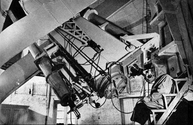
Fig. 31. The refracto-reflector, named the Baillaud Telescope, under the Baillaud dome in 1947. It was with this instrument that the main planetary and solar observations from 1950-60 were made. The instrument was dismantled in 1970 and replaced by a coronograph. Photo © Régie du Pic du Midi and Observatoire Midi Pyrénées
Bernard Lyot, astronomer at the Paris Observatory, supported Jules Baillaud in his astronomical projects. It is to him that they owe their original and audacious character.
In 1942, new 60 cm optics were installed on the Pic. The large 18 m focus is folded up on itself twice, transforming the telescope into a refracto-reflector. Rechristened the “Baillaud Telescope”, this instrument was used with a great deal of success in the 1960s and would become the instrumental flagship of the Pic.
After the war, the main projects that had been prepared by Jules Baillaud and catalysed by Bernard Lyot would finally be completed. The rise and influence of the Pic du Midi could begin.
Infrastructure: renovation of the first buildings and completion of the Dauzère building
- 1937: The Nanssouty building was renovated and received a new roof: a reinforced concrete vault. This roof would be more resistant to the conditions experienced on the summit (the weight of the snow and the violent winds are still present today).
- 1946: The wealthy amateur astronomer Marcel Gentili gave the observatory a dome (the future dome of the 1 m Telescope) and a 60 cm telescope, in order to thank its members for hiding him from the Nazis during the war. The new dome was installed on the Dauzère building whose construction began in 1935 and was completed in 1948.
- 1947: The observatory was connected to La Mongie by a cable car exclusively reserved for transporting equipment. The arrival point of the cable car was located southwest of the Baillaud dome.
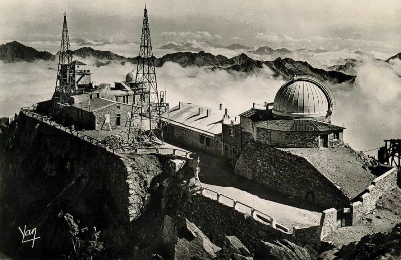
Fig. 32. The Pic du Midi Observatory in 1948. We can see the extension of the Dauzère building to the left of the image, the installation of the Gentili dome, and the Nanssouty building’s new roof. Photo © Yan, Fond Eyssalet
The rise of astronomy and the international influence of the observatory (1947-1981)
Astronomer Jean Rösch was director of the Pic du Midi over the course of these prosperous years. In order to describe this long period under his directorship, he divided it into three parts:
- 1947 to 1952 saw major infrastructure work and the arrival of the cosmic ray specialists.
- 1953 to 1964, the decade following the construction of the cable car, saw the all-round expansion of scientific work and the internationalisation of the Pic du Midi’s reputation.
- 1965 to 1981 saw the project to increase the instrumental power of the observatory with the 2 m Telescope, Jean Rösch’s largest investment.
The “Rösch years” represent a fundamental break with the observatory’s first 50 years. There was a surge in all its components: personnel, infrastructure, instrumental capabilities, and topics of scientific research.
The major infrastructure work and arrival of the cosmic ray specialists (1947-1952)
The arrival of the cosmic ray specialists from Manchester in 1949 brought about a revolution at the observatory. Their presence, their needs and the results of their work allowed Jean Rösch to boost all the major infrastructure projects that would transform the Pic forever. In particular, they needed a means of transportation to bring their electro-magnet to the summit and a high-powered electric current to operate it.
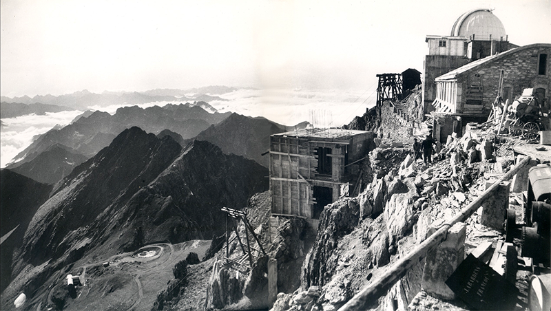
Fig. 33. Construction of the first cable car station on the south side of the Observatory. 1950. Photo © Alix, Fond Eyssalet
Scientific work and results
In 1950, a new particle was discovered at the Pic by the cosmic ray specialists from Manchester. It was named the “Hypéron” during the International Congress of Cosmic Rays in Bagnères de Bigorre in 1953. This discovery was rewarded with a Nobel Prize.
Infrastructure: major works as the Pic du Midi enters the modern era
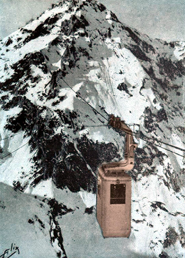
Fig. 34. The first Pic du Midi cable car, the symbol of its entry into modernity (1952). Photo © Alix, Fond Eyssalet
- Between 1945 and 1949, the high tension line was built. This 10,000-volt line came into service on 18 November 1949. The unlimited electrical current attracted many heavy usage experiments. The supporting cable greatly facilitated building extension work.
- In June 1949, a funicular was built in order to connect the hotel in Laquet to the observatory. The installation of this framework on the incline was justified by the Manchester cosmic ray specialists’ need to transport the electro-magnet. The series of mules that had been marching up the Pic du Midi for 75 years disappeared forever.
- On 15 August 1952, the first cable car docked at 2877 m above sea level. The observatory emerged out of isolation for good, bringing with it a complete development of the infrastructure that would accommodate the increase in personnel and meet the expectations of the researchers.
All-round expansion of scientific work and the internationalisation of the Pic du Midi’s reputation (1953-1964)
From this period on, the scientific work is such that it becomes the main factor in the history and development of the Pic du Midi. The facts and events in this section will therefore be explained in terms of scientific work.
Scientific work and results
The cosmic rays decade (1949-1959)
Throughout these ten years, several internationally renowned teams brought to the Pic advanced experiments on cosmic rays. Priority was given to high-altitude observatories at this time because they reduce the destructive effect of the atmosphere on these particles. Furthermore, interest in cosmic rays increased after the 1950s. Indeed, their study provided an indirect way to undertake nuclear physics. The cosmic ray specialists at the Pic can be separated into two categories.
The Manchester team was joined in 1951 by others from the Polytechnic School, led by Louis Leprince-Ringuet. In 1951 he installed equipment that performed better on the summit than that of the Manchester team. According to Leprince-Ringuet, the Wilson Chamber was the largest of its kind in the world. With this instrumentation, they discovered new particles in subatomic matter, which earned them the Cognac-Jay Prize from the Academy of Sciences in 1962. In 1959 and 1960, the accelerators of CERN and Brookhaven brought about the departure of the Polytechnic team from the Pic.
The Sun
Monitoring of the solar corona with the Lyot coronograph in the 1930s was both the starting point and catalyst for solar research undertaken at the Pic in the second half of the 20th century.
Jean Rösch equipped the observatory building with new instruments in order to study the solar atmosphere in its entirety. Alongside the solar corona, it was now possible to study the photosphere and the chromosphere. This work, and its potential, attracted many scientists: Lyot’s "heirs" at the Meudon Observatory and foreign researchers.
In 1955, the study of solar granulation was at the cutting edge of global scientific research on the Sun and the photographs from the Pic were considered the best available. Up until 1987, when the Roque de los Muchachos Observatory opened in the Canary Islands (see case study), the Pic du Midi was the most important solar observation site in the world..
The Moon
The infrastructure at, and high quality images available from, the Pic secured its selection in 1956 to carry out the "Manchester Lunar Programme". In 1959, thousands of lunar images taken at the summit impressed the US Air Force so much that they decided to fund the observatory to map the Moon. This work contributed directly to the Apollo programme launched in 1961. Placed under American management, the mapping of the Moon required the work of more than 50 people at the Pic. In 1964, a 1 m telescope, funded in part by NASA, was installed under the Gentili dome and took over from the Baillaud Telescope for lunar observations. The American Orbiter probes 1-5 were launched between 1966 and 1967, and marked the decline of the “Manchester Lunar Programme”.
The planets and their satellites
As with the Sun and Moon, the quality of the research and planetary images have contributed to the worldwide reputation of the Pic du Midi. The intense development of planetary exploration in the 1950s and 1960s was mainly due to Andoin Dolfus.
Detailed cartography of Mars took place for more than a decade. Henri Camichel was able to determine the length of the Martian day, the diameter, the levelling of the planet, the polar alignment and the orientation of its rotational axis with great accuracy.
The exploration of Saturn at the Pic also provided important contributions to planetary science. In 1966, Dolfus was involved in the discovery of one of the outer rings of the planet, as well as that of one of its small satellites, which he proposed to name Janus.
Venus was also the target of many observations. The work conducted by Dolfus helped highlight the retrograde rotation of the planet, and the four-day "hyper-rotation" of its atmosphere, confirmed in 1972 by the Mariner 10 probe, is considered to be one of the most important discoveries to which the Pic du Midi has contributed.
The study of the soil and atmosphere of the planets and their satellites is the most original contribution that the Pic has made in the field of planetary science. By using a polarimeter, an instrument rarely used at the time, Dolfus was able to deduce the composition of planetary surfaces, notably those of Mars and of the Galilean satellites of Jupiter. The results on the Galilean satellites were confirmed in the 1970s by the Voyager probes.
The 1970s heralded the era of such space probes, and thus planetary research at the Pic—which had hitherto been considered unrivalled—gradually declined.
Infrastructure: expansion in response to the intensification and diversification of scientific and technical demands
Work on the infrastructure at the beginning of the 1950s, and the observatory’s increase in power, led to the extension and construction of several buildings. The Marchand Laboratory was built in 1956, and the Labardens building completed in 1957.
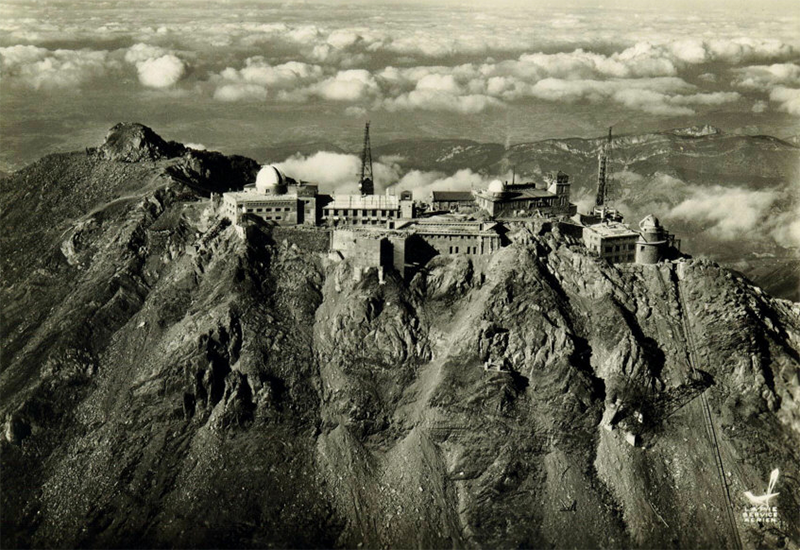
Fig. 35. Aerial view of the Observatory in 1960. The western part of the summit is not yet taken up with the interdepartmental building. In the centre, we can see the new cable car station at the top. Photo © La Pie servie aérien
- 15 February 1961 marked the inauguration of the Tourelle Dome, installed on the eastern part of the platform.
- 1962–1963: The summit welcomed the structure which today makes it recognisable to all: the interdepartmental building with its 103 m-high aerial, which rises to over 3000 m above sea level. These buildings are not part of the Observatory and handle services related to broadcasting, civil and military communications. The astronomers’ influence at the time was such that they succeeded in banning the installation of a light on the aerial.
- 1964: The 1m Telescope, financed by NASA, was placed in the Gentili dome. The Pic du Midi’s great nocturnal telescope era began here.
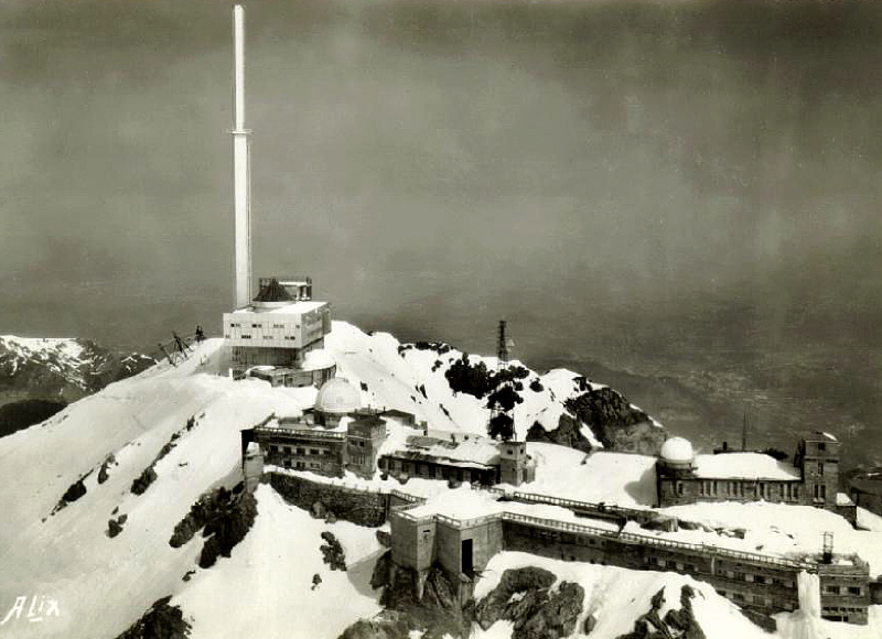
Fig. 36. The face of the Pic du Midi changes for good with the arrival of the 103 m-high aerial and the interdepartmental building (1963). Photo © Alix, Fond Eyssalet
The increase in instrumental power of the observatory (1965-1981)
In 1965, John Rösch began the 2 m telescope project in order to afford the Pic its place in an astronomical context where the reputation of an observatory depends on the power of its instruments. This also served to make the most of the conditions offered by the summit.
The BLT, built from 1970 to 1981, is available to the international community. As the largest national telescope, for several years it was used as one of the tools in an immense research strategy in a multitude of projects across a range of topics.
The John Rösch years marked the highest point in the history of the Observatory. During these three decades, the Pic was consistently placed at the forefront of various themed astronomical observations and contributed hugely to scientific progress in this area.
The years 1970 and 1980 marked a set of technological and international revolutions to which the Pic has tried to adapt. It gradually yielded to the space probes and the giant international and spatial telescopes. Nonetheless, the Pic du Midi’s robust scientific core endures, as the Bernard Lyot Telescope demonstrates.
Infrastructure
- 1970–1981: the construction of the Bernard Lyot Telescope and its observatory building comprises the last phase of scientific infrastructure development on the summit. The initial landscaping work began in 1970, the building was completed in 1976 and the telescope was fully operational in 1981. The construction of the BLT and the aerial are the most important and iconic features of the Pic du Midi.
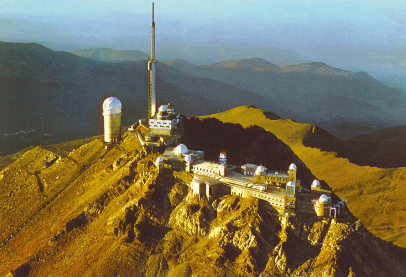
Fig. 37. Aerial view of the Pic du Midi Observatory in 1990. The scientific infrastructure was at its height before the reconfigurations during the 2000s. Photo © Régie du Pic du Midi and Observatoire Midi Pyrénées
The dark years to come (1982-2000)
During the 1980s, France redirected its astronomical policies in order to prepare for the advent of major international observatories such as the VLT. The development of these projects required transforming the management and financing of national observatories. As with the crisis of the 1920s, the continued functioning of the observatory was deemed too expensive and its closure was announced for 1998.
In 1993 the new director, Michel Blanc, presented the “Pic 2000” project. This project was a challenge of reconfiguration: to locate the Pic du Midi on a new technology-oriented university campus and redevelop the site in order to sustain the scientific work at the summit whilst opening it up to tourism. A public coalition was set up in the same year, and the Syndicat Mixte for tourism development at the Pic du Midi was created. A set of public and private partners came forward to help fund what would become the highest construction site in Europe, the work starting in 1996.
In June 2000, the Pic opened its doors to tourism. Since then, its 100,000 visitors a year have allowed the Pic to cover its own operating expenses and continue its scientific work. The observatory has since been asked to develop both these aspects. The tourist activity must reinvent and enrich itself while always preserving the identity and integrity of the site. The scientific work, meanwhile, should be situated in specific fields and excel at these on an international level.

Fig. 38. Since 2007, the Pic du Midi has been opening its doors to tourists at night for evenings dedicated to observation and the discovery of the observatory. The astronomers and facilitators enhance the public experience (2014). Photo © Nicolas Bourgeois
Scientific work and results
Even during the dark years of the Pic 2000 project, the astronomical work never ceased. From 1980 to 2000, the BLT was a universal telescope, available to the international community. After 2000, the instrumentation and fields of investigation of the BLT were rationalised in order to maintain its place in the scale of world astronomy. In 2007, the telescope was specialised for use in stellar spectro-polarimetry using its NARVAL system. This was such a new field of study that the only telescopes practising it were the BLT in collaboration with the Canada-France-Hawaii Telescope.
Alongside the BLT, other telescopes carried on their observation programmes. The 1 m Telescope was operated by the Institute of Celestial Mechanics and Ephemeris Computation (MCCE) in Paris. It specialises in monitoring planetary surfaces and in the study of small solar system bodies. The Rösch Telescope and Tourrelle dome were managed by the PMO and were used specifically for the training of PhD students in astrophysics for observing the solar photosphere. The continued monitoring of the corona was ensured via instrumentation and infrastructure recently installed for the Pic 2000 project. The observers and monitoring were entirely funded by sponsorship.
With the Pic 2000 project, the PMO was able to expand the range and direction of the Pic’s fields of research, including atmospheric sciences. The observatory contributed to the study of atmospheric pollution and transient luminous phenomena.
Infrastructure
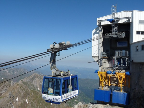
Fig. 39. The new cable car station at the summit and the high-capacity cable car (2000). Photo © Régie du Pic du Midi and Observatoire Midi Pyrénées
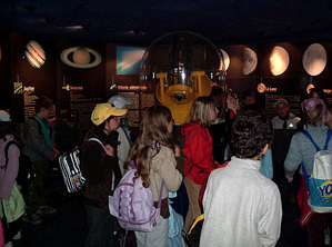
Fig. 40. The Pic du Midi museum space, telling the Observatory’s scientific and human history (2005). Photo © Régie du Pic du Midi and Observatoire Midi Pyrénées
The latest work on the Pic du Midi’s infrastructure was done in order to accommodate tourism whilst preserving the scientific work. This was all done between 1996 and 2000.
- Installation of a high-capacity cable car (300 people/hour).
- Reconfiguration of the platform with infrastructure modifications and the installation of services dedicated to tourists: a museum space in the Baillaud dome buildings to display 140 years of life and science on the Pic du Midi; a restaurant accommodating 80 people; facilities to manage the flow of people, safety and movement on the terraces; refurbishment of all rooms and premises.
- Installation of a new coronograph observatory building on the south east terrace.
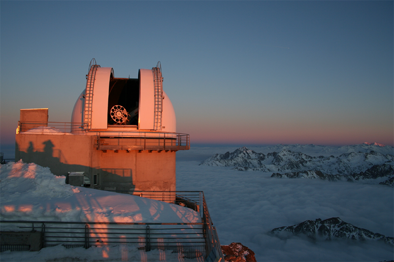
Fig. 41. The new dome and coronograph ensuring continuous monitoring of the solar corona (2008). Photo © Régie du Pic du Midi and Observatoire Midi Pyrénées
Justification for inscription
Comparative analysis
The Pic du Midi’s profile is unique in the great family of worldwide scientific observation stations. Firstly, its history is rooted in the early development of the application of scientific method to nature in the 17th century. It is one of the last high-altitude resorts built in the 19th century that is still used as a window on the geophysical and astrophysical universe. This vibrant site has witnessed evidence of the human desire to gain knowledge in fields as diverse as meteorology, aerology, botany, geophysics, astronomy, and particle physics over the years of its existence.
There are a fair number of observation stations at altitude around the world, but the stations on high mountains can be counted on one hand. The Alpine station, Jungfraujoch in Switzerland, is the last one still open, and the Californian observatories, amongst some of the oldest, are not in the high mountains. The great Andean astronomical observatories are recent.
In addition, the scientific work of all these other sites is dedicated to a particular subject area (aerology for Jungfraujoch, astronomy for the others) or is being severely compromised by adjacent human activities (as is the case for Palomar and all the observatories in urban and peri-urban areas).
The major active sites, the island observatories (Hawaii and the Canary Islands) and the astronomical sites in the Chilean Andes (AURA, Las Campanas, La Silla, Paranal, and ALMA), all have a relatively recent history, starting in the late 1960s for the oldest ones and the 2000s for the most recent. While all these sites convey the feeling of exceptional human adventure, they do not convey the closeness to the historical roots of scientific exploration that is found at the Pic du Midi.
The Pic du Midi uniquely illustrates the power of humanity. Thanks to the perseverance of men and women from diverse starting points (rich sponsors, Pyrenean mountain enthusiasts, committed scientists, shepherds from the valley who love their mountain)—with a variety of motivations but driven by the same enthusiasm—the Pic du Midi has become, and will continue to be, a space where culture, science and art cross paths and complement one another by making the unspoilt beauty of the site and landscape available to everyone.
Integrity and/or authenticity
Integrity
The integrity of composition is satisfactory because all major historical activities are present (foundations from the early 20th century, historic domes, etc.) or represented in the Pic du Midi’s site and its surroundings (buildings with 19th century origins, historical paths, etc.) by correctly identified material evidence. It is therefore possible for the visitor to have a clear enough idea about the past and present of the site.
Today’s structural integrity truly represents the overlapping and correlation of functions historically assigned to the Pic. These activities have been continued since the foundation of the observatory, and the renewal of individual components in accordance with new requirements has always been undertaken in keeping with the original elements..
The functional integrity is marked by the fact that the Pic’s various main activities—scientific observations of the sky and the atmosphere, the welcoming and lodging of tourists and mountaineers, broadcasting functions—have been in harmony with one another right from the beginning and have always complemented one another and been organised around the Astronomical Observatory. The buildings and infrastructure form a whole that serves the well-being of the Pic so that it can continue in its original, historical role.
The quality of the panorama and the night sky are such that the celestial landscape integrity of the Pic du Midi reflects one of the most remarkable, natural properties of the site. The origin of this lies as much in its vocation as a scientific station at high altitude as with its popularity and tourist success (Pyrenees, mountaineering, snow sports, visiting for the view, amateur astronomy, etc.). The conservation of this dual integrity, both by night and day, today presents one of the major challenges for the conservation of the site.
Authenticity
The authenticity of its design rests upon a continuity of scientific, technological and civil engineering initiatives since the first projects came into being towards the end of the 19th century. They can only be understood within the dynamics of the site and the renewal of techniques in order to benefit site development: the creation of domes and scientific instruments, its current evolution, the creation of cable car access, the construction of the great broadcasting tower, and so on.
The authenticity of the components and materials is again based on this dynamic, specific to a scientific station that has had multiple purposes throughout its history: the introduction of reinforced concrete, progress in dome construction, the evolution of architectural structures. A specific feature marking this aspect of authenticity is the respect for existing buildings and the sympathetic superimposition of new structures upon older ones. This has been particularly true ever since the equipment of the early 20th century was installed on the summit: all strata of building constructions and historical scientific equipment are present.
The architectural and landscape authenticity is an issue that can only be understood in terms of other closely complementary aspects. It is a matter of understanding a place of science and tourism that is continuously taking on new forms. It is not possible to judge the authenticity of such a place as one would for classical heritage sites and monuments. The renewal both of the equipment and of the construction framework for both the scientific station and the tourist resort has always been undertaken in a spirit of restructuring the old, but two main components represent a split:
- the construction of the cable car (1950–52), which totally changed the access to the Pic and allowed the site to welcome in the public and remain open all year;
- the construction of the DFT tower (1953) in the second half of the 20th century, which gave the Pic its visual signature as seen from the valley or the adjacent mountain.
The property therefore has a visual authenticity that has evolved alongside its history. The perceived authenticity of the Pic du Midi today seems most important: the newcomer’s first, strong impression while riding the cable car is that of an authentic and original scientific mountain station. One could even say that the image portrayed by the Pic, with its broadcasting tower surrounded by observatory domes, forms the ideal model and symbol of the high altitude Observatory.
The environmental authenticity reflects one of the great values of the property: the quality of its atmosphere and its clear skies. These values are intrinsic to the Pyrenees and are the source of the romantic appreciation of their outstanding tonal range compared to other major European mountain ranges, which motivated the first foreign visitors, notably British, and local élites behind the proposed observatory at the Pic du Midi (see History and Development, above). This sparked the notion that we should have a seasonal and then permanent human presence on the Pic, enabling high-quality astronomical observations (substituting for the Paris Observatory, in partnership with NASA), and finally allowed the development of tourism dedicated largely to the Pyrenean panorama, and more recently to the appreciation of its night sky. The long-term preservation of panoramas, at the highest level of French legislation (see Protection and Management, below), and more recently a major initiative to protect against light pollution (International Dark Sky Reserve project, 2009–2013), the largest in France to date, guarantee the highest degree of environmental authenticity and its future protection.
Criteria under which inscription might be proposed
Criterion (ii): In terms of the history of its construction and development, the Pic du Midi is primarily a national programme that brings together important human, scientific and financial capabilities, on both a regional and national level. Owing to the quality of its night sky, the Pic took over from and substituted for the Paris Observatory, itself a leader and promoter of very important international scientific programmes. From the 1930s, and especially during the second half of the 20th century, the Pic du Midi Observatory developed international collaborations in astronomy. In particular, it served in the 1960s as an observation centre associated with NASA and the conquest of space.
Criterion (iv): Today, the Pic du Midi represents the ideal model and symbol of a high-mountain observatory. It belongs to the older generation of such observatories, designed and built towards the end of the 19th century. Over time it has gradually changed its use and today it offers a veritable landscape and cultural icon, visible from far away, showing both the human presence at altitude and the scientific use of the high mountains. The quality of its climate and atmospheric environment is responsible both for its daytime panoramas and its exceptional night sky, qualities that underpin its scientific value as much as its tourist reputation.
Suggested statement of OUV
In terms of UNESCO categories, it seems reasonable to consider “Cultural Landscape” for the Pic du Midi. This would fit well with the value assigned to the site, its situation as a mountain peak, and its general shape as symbolic value. It is also consistent with two very important environmental values: the view of the central chain of the truly remarkable Pyrenees by day, and an equally outstanding situation by night owing to the quality of the night sky.
Potential "Outstanding Universal Value" (OUV) could be based on the following:
- The Pic is a high-mountain observatory amongst some of the oldest (the comparative analysis will be important on this point).
- It includes a comprehensive set of material testimony to its different historical periods of occupation (domes, instruments, technical equipment) spanning more than a century of scientific use in the high mountains.
- Beyond this, it is a pioneering scientific and technical station at altitude with a number of other uses (weather observations, broadcasting, etc.).
- The Pic has had continuous scientific use, particularly for astronomy, and has always been a place alive with astronomy.
- The importance of the scientific work at the Pic du Midi, world-class innovations (coronagraph), and international cooperation.
- It represents a major natural and cultural landmark in regional history. Its silhouette is unforgettable, as important a symbol of the Pyrenees as physical geography manuals. It is a symbol of the peaceful relationship between humankind and the high mountains.
- It is a place of exceptional observation by day and night, to which the Pyrenean panoramas and the quality of the night sky are testament.
State of conservation and factors affecting the property
Present state of conservation
The buildings and observatories are regularly maintained. However, this maintenance is extremely complex and sensitive. See the section “Environmental Pressures” below for more information.
Factors affecting the property
Developmental pressures
The exceptional location of the Pic du Midi means that it escapes most of the pressures linked to urban or industrial development.
However, the presence of the nearby ski resort of La Mongie has, on occasion, resulted in the Pic being exposed to expansion projects to enlarge the skiable area. But the desire of the local elected officials to preserve the observatory’s integrity has always succeeded in keeping these attacks at bay.
Environmental pressures
The first is the high altitude and strong assaults it inflicts on buildings. Rain and melting snow seep into buildings. When temperatures drop, the water freezes and shatters the masonry. There are also very strong winds that can reach nearly 300 km/h, or thermal amplitudes reaching nearly 60°C. Without permanent maintenance work, the Pic would fall into ruin in fewer than 5 years (as happened during the First World War).
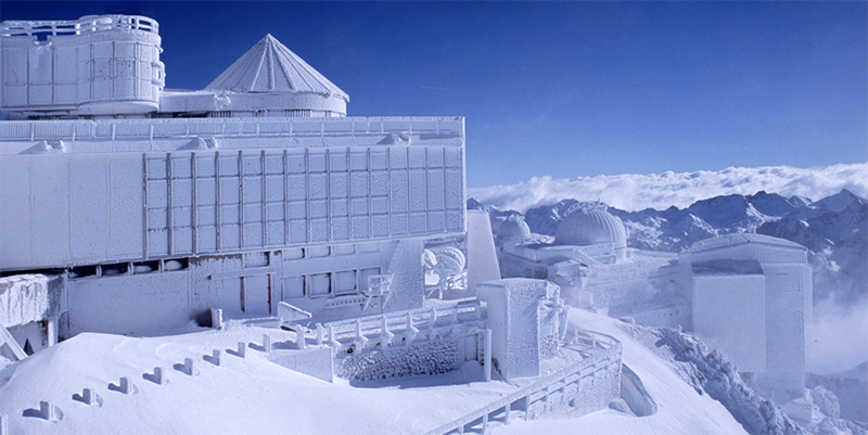
Fig. 42. Winter at the Pic du Midi. The buildings are imprisoned under the frost and the snow (2008). Photo © Nathalie Strippe
The second reason is the complexity and variety of the buildings. One hundred and forty years of facilities and construction are superimposed on the summit. Modern concrete buildings are mixed with stone structures from the beginning of the 20th century and the whole assemblage spreads over 1 hectare of ground and reaches nearly 8 floors in height. The maintenance of an edifice of this size and diversity at nearly 3000 m above sea level demands considerable attention and resources. These are not sufficient to ensure the homogenous integrity of the whole platform.
The final reason, also related to the altitude, is the seasonal maintenance. Throughout its history, major work on the Pic du Midi could only be carried out during the summer (July to September) and modern methods can do nothing to change this.
The Pic du Midi’s night sky today is still of very good quality. However, the increase in light pollution observed for more than twenty years in this region has alarmed both astronomers and elected officials of the Pic du Midi. In order to counter this threat, the International Dark Sky Reserve project was launched in 2009. The Pic du Midi, accompanied by an extensive network of partners, is committed to completing this process, which goes beyond just the issue of access to the stars.
The 251 municipalities that make up the Reserve in the Hautes-Pyrénées are currently mobilising to support the sustainable development approach. Among the main actions that characterise this project are the establishment of a new mode of economical, sustainable and cleaner lighting, the protection of the sky and the nocturnal environment, and tourism development. On 19 December 2013, the Pic du Midi IDSR was accredited by the International Dark Sky Association, making this Dark Sky Reserve the first in France and the second largest in the world. Today, 40,000 public street-lights are involved in the programme to improve the lighting. The monitoring carried out by this programme measured an 85% decrease in the luminous flux emitted upward in converted villages. Since 2012, approximately 3000 lights have been improved each year.
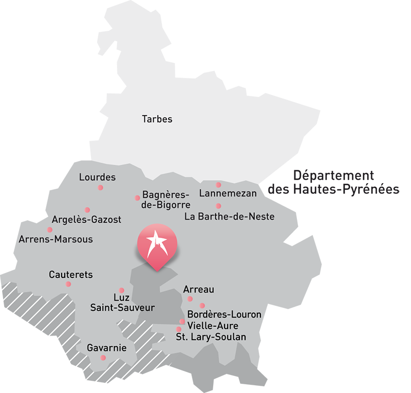
Fig. 43. Pic du Midi IDSR. The IDSR, with its core and buffer zones, takes up 65% of the territory of the Hautes-Pyrénées’ département. Photo © Agence Hotel Republique, Régie du Pic du Midi
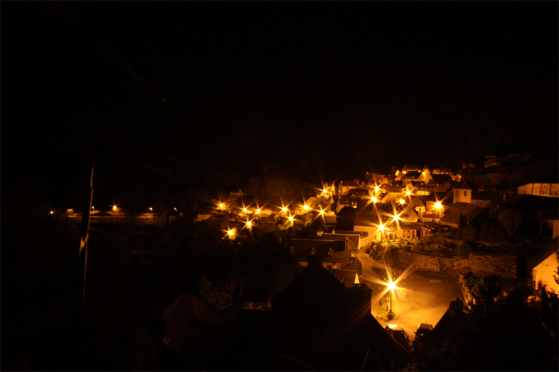

Fig. 44. Lighting in the village of Aulon, before and after the improvements made to the lighting under the Pic du Midi IDSR project (2013). Photos © Léa Salmon
Natural disasters and risk preparedness
Natural disasters in the Pyrenees affect the Pic du Midi indirectly. They disrupt the flow of tourists upon which the observatory’s work now depends. In June 2013, heavy floods affected the Hautes-Pyrénées, destroying many access roads and making them impassable for several months. The Pic du Midi in general, already very sensitive to bad weather, saw its attendance drop by more than 30% that year.
Visitor/tourism pressures
Tourism is now essential to the work of the Observatory. The “Pic 2000” project was the fruit of collective work between astronomers and local public authorities, helping to redesign the platform and its access in order to welcome the public without transforming or disrupting the scientific work. Most of the tourists visit during the summer. However, the Pic stays open for visits all year round and only closes for maintenance periods in November and April.
Number of inhabitants
The observatory has 10 permanent residents and an average of 5 researchers on the summit. However, the number of staff members that allow the Pic du Midi to operate is much greater. The Syndicat Mixte of the Pic du Midi and its technicians have over 50 employees. The Midi Pyrénées Observatory platform technique team is made up of 20 people. The Pic, as a university training centre, also welcomes many trainees and PhD students.
Protection and management
Ownership
Currently, two agencies manage the Pic du Midi Observatory and its infrastructure.
The buildings carrying out the scientific work are in the public domain of the French state. Their management is provided by the Paul Sabatier University in Toulouse via the Midi Pyrénées Observatory. The MPO is thus responsible for 4000 m² distributed amongst the various observatories and technical areas related to science.
Since 1996, the Syndicat Mixte du Pic du Midi has been the new observatory concessionary. It is in charge of tourism infrastructure, technical elements (purification of the summit station, pumping station, generator), access to the site (and cable car stations) and human resources (rooms, staff rooms, meeting room). This also represents 4000 m².
There is one final concession at the summit, which is outside the Pic du Midi Observatory. This concerns the Interdepartmental Building, which is the property of the State and managed by the French broadcasting organisation Télédiffusion De France. This makes up 2000 m².
Protective designation
In 2003, the Pic du Midi became a “National Natural Site” under the heading “Landscape Beauty”. This document, issued by the Ministry of Ecology and Sustainable Development, protects the integrity of the panorama terraces accessible from the observatory.
Since 2007 the observatory has been involved in a voluntary environmental quality programme in order to reduce its impact on the natural environment. It obtained the international “quality, safety, environment” certificate via the ISO 14001 standard.
The Pic du Midi is also the only tourist attraction at altitude to have achieved, on its own, the level of security required for an establishment to open its doors to the public. The observatory is certified to ISO 9001 Version 2000 in security, infrastructure maintenance and public management.
In 2013, it received International Dark Sky Association accreditation for the preservation of its night skies (see the section entitled “Environmental Pressures” for more information).
Visitor facilities and infrastructure
The observatory is equipped to accommodate an average of 100,000 visitors per year while preserving the architectural integrity of the site and its scientific work. For details, see the “Tangible Heritage”, “History and Development” and “Integrity and/or authenticity” sections.

Fig. 45. The terrace on top of the Pic du Midi in the summer. Tourists today have access to 750 m² of terrace, the museum space under the Baillaud Dome, and the restaurant in the Vaussenat Building (2013). Photo © Nicolas Bourgeois
Presentation and promotion policies
The Pic du Midi is considered a Mecca and geosymbol of the Pyrenees, of human adventure and of science. Because of this, it is the subject of several development and protection policies.
In 2010, the Pic du Midi was chosen to be part of the “Grands Sites de la Région Midi-Pyrénées” (the Midi-Pyrénées’ Great Sights). This label values natural and cultural sites as well as the most iconic architecture of the Region.
Documentation
Photos and other AV materials
A photographic inventory of the Pic du Midi property is being developed within the Ramond Society and the Pic du Midi Observatory.
Most recent records or inventory
See the section entitled “Movable heritage objects—small instruments, books, archives and photographs” for the Pic du Midi Observatory heritage inventories.
Bibliography
Charlier B., Bourgeois N. (2013). ┬½Half the park is after dark. Les parcs et réserves de ciel étoilé: nouveaux concepts et outils de patrimonialisation de la nature.┬╗ L’Espace Géographique, 42, 200–212.
Cortella P. M. (ed.) (2009), ┬½Pic du Midi de Bigorre, portes ouvertes sur le futur.┬╗ Bulletin Pyrénéen, 239.
Davoust E. (2014), Pic du Midi, Cent Ans de Vie et de Science en Haute Montagne. Barcelone: MSM.
Dollfus A. (1961). The Solar System, Vol III, Planets and Satellites. Chicago: University of Chicago Press.
De Marco R. (1997). Le Pic du Midi, le Sommet Reconstruit. Mémoire de DEA, EHSS, Paris.
De Marco R. (2003). La Construction du Lieu ├á l’Époque de l’Utopie Véritable: Le Pic du Midi de Bigorre. Pour une Connaissance Sensible et Faisable du Lieu et du Paysage. Thèse de Doctorat, EHSS, Paris.
Martin H. (1989). ┬½Menaces sur le Pic.┬╗ Pyrénées Magazine, no. 1, 16–27.
Sanchez J. C. (2014). Le Pic de Bigorre et son Observatoire. Paris: Cairn Editions.
Terrancle P. (1995). ┬½Pic du Midi, voyage ├á l’intérieur d’un mythe.┬╗ Pyrénées Magazine, no. 37, 20–35.
Terrancle P. (1997). ┬½Pic du Midi, le grand projet.┬╗. Pyrénées Magazine, no. 54, 58–73.
No multimedia content published
Currently there is no multimedia content published for this case study


